Sunday, January 29, 2017

Lost Lake

Lost Lake

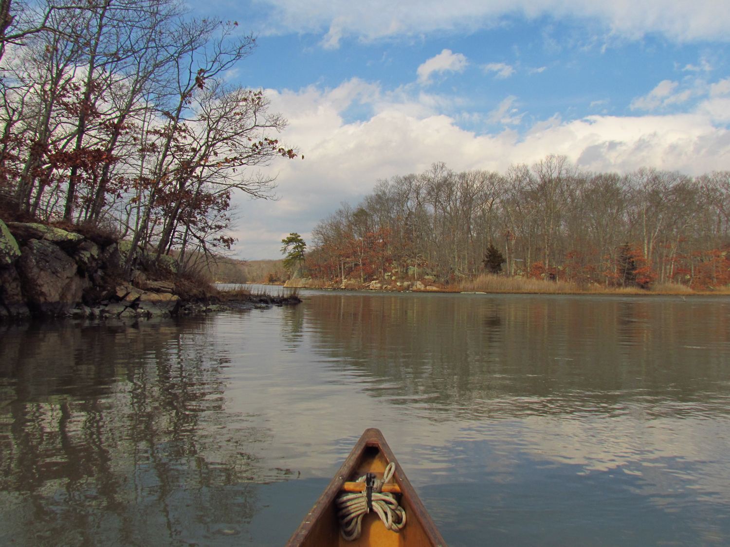
There's a strong wind off of the sea and a fast tidal current jetting through the narrow gap that connects the marsh to salt water.  But once I am in the canoe, seated low, the wind is not so much a bother and I ride in relative comfort inland towards my destination.

After paddling a half mile through a broad salt marsh I reach the road where I have to do a very short and easy portage into a small pond.  The culvert that connects the pond with the marsh is too small and fully submerged with a powerful current rocketing through it.
1891

I quickly reload the canoe and head up to the narrow arched railroad bridge.  The keystone of the arch has 1891 chiseled into it.  There is little current as the culvert at the road is acting as a filter, slowing the passage of water that would have made this gap a fast ride.

It is a secret garden passage, a narrow arched tunnel that enters a beautiful lake surrounded by forest with short cliffs and steep hillsides descending into the lake.  I immediately flush a kingfisher and a great blue heron.  But soon I discover a problem.  Almost everywhere it is surprisingly shallow.  The water is 6 to 8 inches deep in most places with a soft layer of silty mud beneath.  When I lose the deep channel I decide to cross the lake at a narrows and probe for any depth.  Most shallows have a deep channel...but this does not.  I continue a shore ways and it stays shallow, so I head back out knowing how long it might take to extricate myself from a mudflat.
Lost Lake

At one time this lake was probably just an extension of the sea.  Then a railroad was built with just a narrow opening to let water pass.  For a 126 years the flow of tides have been restricted to a trickle of what it once was.  It has been slowly filling with silt ever since.  I suppose that the shallow water gets quite warm in the summer, the bottom absorbing the suns energy with no deep water or current to carry the heat.  It may possibly be too warm for a lot of plants or fish to survive.  Some day it might be a meadow - it's not much different than a large beaver pond.

salt marsh
On my return I poke around in the salt marsh.  It is quite spectacular even if it won't contain my canoe for much of a trip.  As I pull out I have one of those wonderful Connecticut experiences.  I meet a woman who lives a few yards off.  B and I have a very nice talk, a talk more than long enough for a chilling windy day.  She tells me that the tidal lag on the lake is 3 hours...the lake is deepest (about 15 inches deeper than on this trip) 3 hours after high tide. 
salt marsh

Saturday, January 21, 2017

Ox Meadow Research

I pass by the new spot that I haven't yet explored thinking that it will be a longer and more predictable trip if I I wait for a high tide.  I return to the same place as yesterday. This time, I head up the Neck River, which connects with the East at the sea.

Posts at the big bend
This is a continuation of recording the exposed cultural remains at low tide.  I'll ignore the outside bank as it is currently used by nearby home owners.  The inner bank has no tenants.  At the first bend I find several wooden posts...inside of the bend just like I found in the East River.  But, I also find the first sign of the corduroy road.  And, as I continue up the Neck I come across the corduroy every hundred yards or so...saplings, branches and limbs sticking out of the bank horizontally and laid parallel to each other.  They protrude from the bank about 2 ft down below the top of the marsh.  The ends are cut at an angle - axe cuts, the thicker pieces have been split to crude planks.  This continues until I reach the broken tidal dam just inside Bailey Creek.  The last corduroy is lined up such that the path crossed this dam and then turned down river.  A few of the logs in this corduroy are saw cut, but most are by axe.

Corduroy farm trail
I don't know how fast a salt marsh builds up, but I guess that a 1/4 inch a year might be not too far off.  That dates the corduroy to a 100 years before present.  All things are connected however, and this bodes not well for the marsh.  Sea level rise due to climate change will easily outpace my 1/4 inch per year guess.  These marshes will disappear, its only a matter of time.
Very obvious corduroy farm trail

I head up Bailey Creek finding no more cultural stuff.  I chase off a few hooded mergansers at a couple of the bends and then I spy a half dozen black ducks up the long cut that leads toward the railroad.  I drift back for a photo and find only three.  Then, ten rise up from a hidden spot, then 20 more, and then 20 more.  There is more water up that cut than I suspected.
More obvious corduroy farm trail

On the way out I turn and head farther up the Neck.  After I do a couple of full circle meanders it occurs to me that I've not been here in a good while.  A guy and his dog come down to the water and I get my photo taken.  We start to talk.  It is one of those delightful Connecticut things...you start talking with someone that you've just met and 45 minutes goes by.  R fills me in on some details.  The big marsh was once called (and still is by some people) Ox Meadow.  It was part of a large farm and the broken tidal dam was probably the bridge leading out to the salt hay (spartina).  This all dovetails in nicely with the corduroy trail...the only reason to build that would've been to keep wagons and farm machinery from getting mired.  Oxen pulled equipment makes sense with the guessed age of the path as well.  He also tells me of some foundation ruins that belonged to the last farmer.  He had an airplane and story has it that the foundation was for his hanger. 


On my last stretch of the Neck, I stop and talk with a guy getting ready to go out sailing.  And, I hear the hanger story again.

Friday, January 20, 2017

They

One of the advantages of wild places - even barely wild places - is that they can't get to you.  You don't have to listen to what they say, you don't have to worry about what they want you to do or what they think.  At least for the time being, they don't exist.  They don't like things that they don't control.  One of the unspoken beauties of wild places, aside from the beauty, is that they are rankled by its existence.


I set out at low tide in a river that I know but seldom see in this state.  The mud banks are fully exposed, the base of the spartina above my head, I always feel like I am going back in time when the years of built up primordial ooze is exposed.  I set my camera to sepia tone to match the mood.

planks - likely a tidal barrier to a long cut in the marsh
These conditions give me a chance to explore the "cultural" of the marsh.  As salt marsh, everything that isn't silt or grass is a likely candidate for cultural.  Masses of cobbles...cultural.  Wood firmly fixed in the mud...cultural.  And this is what I focus on, the wood posts and poles that stick out of the bank.  They are firmly fixed, set with intent and perhaps some knowledge and skill, but far from being engineered.  Coming from parts west, I see them first as fence posts.  But, imagining with my more recently acquired east knowledge I know that that is unlikely. 

Agriculture arrived here pre-wire fence.  By the time barbed wire was invented, everything that needed a wall already had a stone wall.  The forests here are littered with stone walls running in all directions.  The posts I am most interested in are away from any trails, roads or paths.  They are isolated.  I suspect that they might have been set to hold fishing nets, or to mark oyster allotments.  I find most of them on the inside of bends and usually grouped, a half dozen scattered about, probably set at different times.  Some are poles from tree limbs, some are sawn lumber.  None of them have any nails or fittings, not that I would expect to find them.  All of them are submerged daily.  Kept wet they rot slowly. Dating them would be difficult.
Cobbles - possibly a crude tide dam

I spot no birds at all until I get to the big bends.  Around the first bend I scare up 15 Canada geese and a couple of black ducks.  After the last bend, the third, I flush a hundred ducks...blacks or mallards by silhouette and call.  Just before the stone arch bridge I spy two blue jays and a kingfisher.  It seems like a lot of blue on such a grey day.

I turn back from the bridge intent on enjoying the calm air and easy paddle that I did not experience yesterday.

Thursday, January 19, 2017

Memory Stick

I put in just upstream from Whalebone Cove near the ferry slip.  I often start on the other side of the river but try not to make crossings like that during the winter.  But caution aside, it is dead calm and the big river is near glassy smooth.  I head down with a comfortable following current.


It is an easy paddle down to the entrance to the channel that takes one behind Selden Island with little to note other than a long steady set of probable deer tracks that have been washed once by the river, and that I have forgotten my notebook.

Making my turn into the back channel I flush a great blue heron, twice.  Then, before entering the large pond at the bend I flush fifty common mergansers.  They go when I am still 300 yards away...skittish.  There's a good number of birds here, a couple swans, a flock of mallards and some Canada geese on the far shore.  As I head down the channel I spook some more ducks.  It shows that hunting season has just finished - they fly when I am quite some distance away.

Besides the birds, I keep my eye out for sign.  By the half way cliffs I find the first beaver sign.  It's not much, just one downed tree, and there are none of the other markers - scent mounds, lodges or obvious drags, but they are around.

I head up into the Elf Forest, a place I've not been into at low tide.  I find more than enough water to get most of the way in.  I find fresh beaver sign along the bank...very fresh.  But again, no scent mounds or lodges, no tracks or drags.  They're probably using the side channels that are dry at this tide level for drags...at higher tide they can just float their cuttings.

The wind has come up while I have been nosing about.  It doesn't seem too bad and the weather prediction was for light wind so I continue down to make my return in the wide main channel.  This turns out not to be such a good idea.  Hoping for better gets me halfway up the island with nothing but worse.  Both wind and current against me, it is a grind.  The camera gets put away - no time to mess with it.  It is bad enough that when I have a long stretch of beach I hop out and tow the canoe...more than doubling my speed while giving me a chance to beachcomb.  It takes twice as long for the return...but well more than twice as much effort.

Connecticut River and Selden Channel

Monday, January 16, 2017

Indian River Bridges

I stop at the new deadfall that has come down spanning the river remembering that I did not remember to pack my saw.  I am an hour out with a headwind on the return, so I decide to use my time to explore other spots on the way out instead of using it to clamber over and around the obstruction.  I my next trip here I can clear a passage in 20 or 30 minutes.

loon

There is little ice on the water except in the harbor and most of that is older and attached to the shore.  Only in one short stretch do I have to touch ice and that has been broken to a chum by the oyster boats that are still going in and out of the harbor on a daily basis.

the first bridge
At the mouth of the harbor I spot 8 buffleheads and one loon.  I find a second loon at the narrows halfway up Gulf Pond.  Loons can be found with fair certainty where there is a current, which I'm sure aids in their submerged fishing.  Gulf Pond holds some geese and black ducks, as usual at this time of year.
the railroad bridge
The flood current shoots me under the railroad bridge - timing is everything on this route as the water backs up a foot or so high at the narrow opening.  I spook a flock of 15 common mergansers as I come out of the passage.  Here starts the Indian River.  It winds it's way along through a wide wetland that keeps the surrounding town at a distance. The tight bends can bring one close to a variety of waterfowl.  I spotted a least bittern on my last trip.  This time it is some mallards, some hooded mergansers and a few wood ducks at the deadfall that marked halfway.short passage.
the lowest bridge


Sunday, January 15, 2017

First Trip of the Year

It snowed last night, a couple of inches of dry fluff, and morning came in the low 20's with clear skies and brilliant sun that warmed the day quickly.  I put in at the marsh dressed plenty warm, almost too warm as it doesn't seem right to not feel a bit of a chill when outdoors in winter. 

I set out up river along the edge of the marsh poking into the narrow inlets that branch off into terra firma.  I noticed a bald eagle perched in a tree behind someone's house and thought how cool it must be to have an eagle in the yard.  But, it turned out to be a squirrel nest with a patch of last nights snow on top.  The big marsh was still, no birds, no animals, and no people other than myself.  It wasn't until I got into Beaver Creak, up in the corner of the marsh, that things came alive.  It began with the startling of a hooded merganser that surfaced from its feeding dive just 10 feet from the boat.  It startled me as well.  Then, I began to flush black ducks...2 or so every 75 yards it seemed.  Then a large flock of mallards, and a hawk, and a kingfisher.  A great blue heron flew low along the distant bank.  All the neighbors seem to be up here in the creek.


On my way out I headed out towards the main river and followed the Nell's channel seaward.  Very quiet...at least the spartina is still standing tall and red gold.  We've not had enough snow to knock it down.  If it stands until spring it will provide some cover for the spring migration...I won't see as many birds, but I think I'd rather have the tall grass instead of a trampled mudflat.

One thing that kept me off the water is the setting up of my exhibition at Norwalk Community College.  It's called "Third Level Landscapes".  I have 51 canoe paddles suspended in the air with over one hundred found objects and drawings on the three walls.  The exhibition is up into mid-March.

Norwalk Community College

Specimen boxes - wood, copper, and found objects

panorama - an great and unusual gallery space