Friday, October 26, 2012

The Unseen Treasure

I portage over to the harbor to put in on the steep rocky bank.  An osprey arrives and begins to hover...it drops with great control and pauses at 15 feet...then it dives into the water and comes up empty.

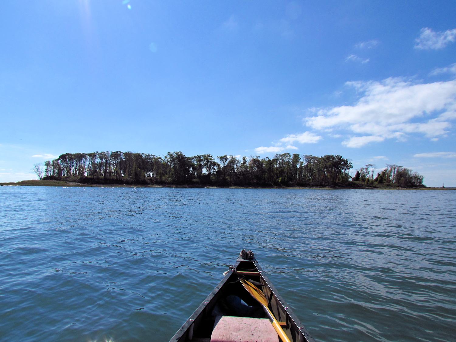
I'm heading to Gulf Pond once more, but this time with plans to get into Indian River.  The tide is dropping and there is enough room for me to pass under the rusty bridge, but the current is as strong as I've yet seen it.  I make very slow headway into it until I get to the bridge.  I reach up with both hands and grab the beams and hurl myself forward.

lower Gulf Pond - near high tide

In the pond, a heron sits on the osprey nesting pole and the feral parrots are making a racket at some distance west.  At the current tide level, I can paddle the edges of the spartina easily clearing the mud flats that are some 3 or 4 feet deep.  I hear a kingfisher in the distance and spot it some 300 yards off.  Some people have told me that I am eagle eyed, but I am not.  That kingfisher is nothing more than a blue-gray dot on the background of autumn leaves.  It is the way that the blue-gray dot moves that tells me it is a kingfisher.  It is a readable pattern not much different from a sheet of music or Morse code.  The trick is to learn the code and you learn the code by practicing the code.

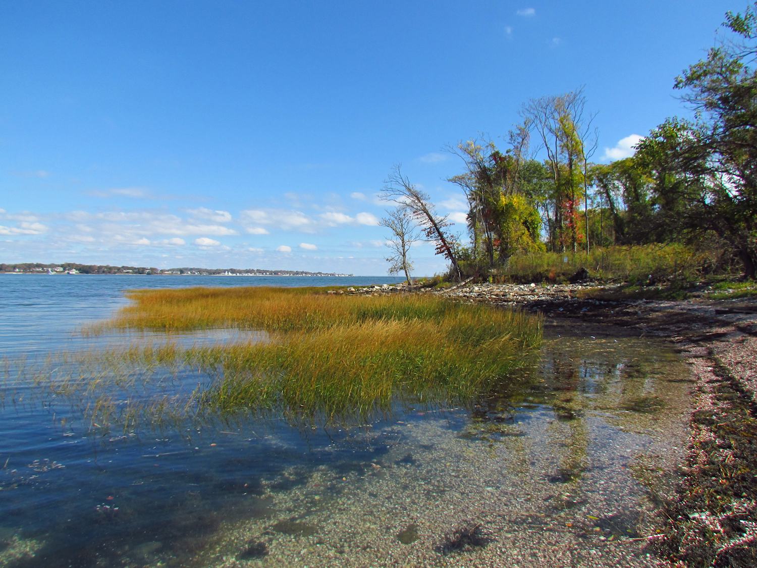
the passage into Indian River


I find the Indian River, where it passes under the railroad, to be too fast to paddle against and a bit too deep to wade or portage, especially when there is no hurry.  So, I take some time to just sit, and every once in awhile, I go check the water level to see how it changes as the tide continues to drop.  When I figure the wading to be no more than knee deep, I nudge the canoe up against the left wall, grab the bow line, and step out onto the rocky bottom pulling the canoe behind.  At the far end, I get back in the canoe and give a strong shove to the wall and coast clear of the current.


It is a river. 

It winds in big bends through marsh grass and phragmites.   The bottom is silty mud, the shellfish are gone, but there are kingfishers and hawks and tiny crabs with one enormous claw as big as their body.  In a half mile or so I get to the I-95 bridge.  It is noisy. 


But here, the river changes and I come out of the underpass into a narrow tree lined river, lined with brilliant rust and orange leaves.  Even the water has a sparse carpet of leaves.  The banks climb higher as the river is incised into the rising ground.  The meanders tighten and come more frequently. 

this is surrounded by unseen shopping malls

This is one of those unseen treasures where everything seems wild and natural over the objections of highway noise.  I've been to places like this before.  Most people never know they exist, they would never think to look here.  I am not even sure of my location since there are no visible landmarks.

I turn around when I get to a log jam that would take too long for my day.  I return home wet to the knees and splattered with mud, just as it should be.

Tuesday, October 23, 2012

The Black Crowned Night Heron

I head upriver from the feral cat park.  There is a couple hours of ebb tide to go and I work against a stiff current, my eyes level with the high water mark on the reeds, which with the sun filtering through has a dizzying hypnotic effect.

I round the first bend in the bank and find a kingfisher to escort me upstream.  When I get even with the first island, Fowler Island, I head across to it hoping for a little less current but instead finding out that I was just about to flush a small adult bald eagle, if I hadn't changed course.  While I take a short break to eat an apple, the kingfisher hunts for fish.

Canada geese


I hear distant honking of Canada geese.  I find them some hundreds of feet overhead, a flock in v-formation, a flock of maybe 30.  It has been a long time since I've seen the big vee's of geese in migration.  My last home was more of a wintering/summering ground, but here I am in a flyway.  Down here at the river level it is more a day for raptors.  I catch distant sightings of hawks that I am not familiar with and shoot the best photos that I can so I can ID them later.


At the second island, whose name has been dropped from modern maps, but is labeled "Great Flat" on an old one, I paddle the east channel.  But, soon I find that the east channel doesn't go through at this tide level, so I return.  As I do, I spot a small mammal swimming toward me, and since mammals (and tracks and other signs) are one thing that I've noticed a shortage of, my curiosity is up.  I have not seen this swimming beast before - it is not muskrat, beaver, otter or mink.


It swims straight for the canoe and turns out to be a squirrel.  I get out of its way...it has no intention of turning, and it does not, and when it gets to shore, I watch it bound up into the brush.  I once had a powerful dream about a squirrel in my canoe...it made the center of the boat glow.

As I paddle next to the shoreline I continue to catch a pleasant odor that I remember, but cannot place.  It has a sweetness to it, but more.  It takes a couple miles of paddling before I place it.  It is fall leaves.  For so long I have lived in a region that was dominated by evergreens.  Here, by such an overwhelming number, the trees are deciduous and I had forgotten the smell of damp leaves as they turn red, yellow and orange - leaves that are still on the trees and not moldering.

The shore alters between silty sand, grasses and reeds, and grey bedrock with the layers tilted skyward.

Again, the distant honking of geese.  By now it is a half dozen large vees that have passed over, all at high altitudes.  I stop for lunch on the cobbled beach below a steep hillside and across the channel from Wooster's Island.  I am at the base of Turkey Hill, the last place where the local Native Americans were granted a place to live - that was a long time ago.

I continue upriver another 45 minutes until I get to the point where I know that I will pay for the return trip with fatigue.

Nearly finished, I spot a shadow on a log overhanging the water.  There is a second gray shadow as I near.  Then, they come into focus.

Four juvenile black crowned night herons


Sunday, October 21, 2012

Soul Ship

I put in on the sandy shore on the ocean side of the rusty bridge and bust the contrary current of the ebb tide into Gulf Pond.  The mudflats are becoming exposed showing their decking of clam and oysters.  The sea meadow grass is a hundred or more yards back, these flats being too deep at high water for the grass to survive.  Autumn colors are showing around the pond, strong reds and yellows in some spots, fading greens in others.


I was greeted at the put in by a flock of wild parrots some 2 dozen strong.  I did not expect this, but I was not surprised.  When I first entered the pond, I was wondering where the egrets might be.  An osprey flew by, the ring billed gulls were there and a kingfisher rattled from the lower branches of the trees.  But, when I got halfway up the first part of the pond, near the shoreline for the graveyard, there were the snowy and great egrets, and a yellowlegs and some black ducks.  A pair of Canada geese flew over, and the town was still quiet enough that I could hear the echo of their honking.


After an hour I returned to the sandy beach to collect S and take her along.  We paddled the full length of the pond, our first canoe outing in many months, if not a whole year.  We repeat all of those sightings adding one single ruddy duck that was swimming near the middle bridge.  It is S's first time in these village waters and she absorbs the newness of it.  More important to me was that she is back in the canoe, inside the most special of places where my soul is unguarded.

Thursday, October 18, 2012

Treasure Hunting

It is a calm and sunny day once again, a day calm enough that one must make use of it to do things that can't be done on other days.

I portage through town and put in on the steep bank at the top of the harbor.  Then, I paddle out to where the harbor meets the sound.  I had two plans in mind, and it is so calm on the salt water that the trip to Charles Island wins out.  From here, it is a mile and a quarter of open water to the small island where it is rumored that William Kidd buried some treasure.  It is now a state park and one of the east coast's best heron and egret breeding colonies.  It is off limits from May to September to protect them.  There is a tombolo connecting the island with the mainland so people can walk to the island at low tide...and they can get swept away at high tide.

Charles Island

The bulk of the island is about 15 feet high and forested with tall, thin and scraggly trees that show their vulnerability to sea weather.  The island interior is fenced off so that visitors are limited to the shoreline.  There once was a religious retreat here and at another time, a fish fertilizer operation. 


The fence probably helps to protect the ruins as well as the birds.  I circle the island, it is less than a quarter mile long, and stop twice to walk the shore.  The beach is almost entirely made of shells that are much closer to whole shells than to the sand that they will eventually become.


I return the way I came and opt for going into Gulf Pond, this time at high tide.  There is a strong flood current going under the bridges.  The old retired rusty bridge is perhaps high enough that my canoe might clear by an inch.  Perhaps it is not that high.  There is no turning back once the canoe is in that flow, so I beach and portage across the road instead, staying dry for sure.  A bald eagle flies by.

At near high tide Gulf Pond is a whole new body of water and I am not restricted to the 10 yard wide channel that flows through.  In fact, the paddling area is probably a 100 times larger.  But, the bird life is much less.  The shallows that would bring herons and egrets are too deep for them to hunt.  There are only one or two visible in the whole pond.

I paddle up to the bridge that divides the pond in half.  This second bridge has even less room under it than the first.  Rather than portage again, I go off left and right exploring shallows that were exposed mud flat on my last trip. 

I find an osprey in a tree on the west side.  We watch each other for a time until it feels comfortable enough with my presence to go back to its business.  That is when I see that it is holding a large fish in its right talon.  I shoot a zillion photographs.

note the fish

I take out at near rusty bridge and do the longer portage back home.

Wednesday, October 17, 2012

Deer Spotting

I head across the river to Pope's Flat, the ca 1900 name of Pope's Island and one that I prefer because it does neatly describe the geography.  It is a calm day with the sun filtering through a haze of high cirrus.  There is an hour or so of flood tide left to come.

I paddle towards the sea following the east side of Pope's Flat and round its point in small eddies to cut over the next channel to Long Island (not the Long Island that you are thinking of).  There is a pair of great blue herons taking off and landing repeatedly and my eye follows their movements until I spot two deer looking at me through the sea meadow grass (spartina).  It is a doe and and a yearling and they bound away from me long before I get anywhere near what one would call "close".  When I reach the point of Long Island I head across the next channel to Carting Island.  Scanning the shore as I paddle, I spot the two deer again.  They have, in that short time, swum across the channel and are now trying to find footing to get up onto Carting Island.  I watch them disappear into the reeds.


The next stretch is a downriver up-current paddle passing under three bridges in short succession.  Then I follow the less protected east side taking advantage of the calm day.  After a time, I cut out into the open water heading for Pepe's Rock, the concrete remains of an old navigation marker with "Pepe" painted on both sides, and then for the bottom of Nell's Island, which is much of the estuary that forms the Charles Wheeler Wildlife Refuge.  I spot quite a few black ducks.  For about 20 minutes, I think that I am paddling the edge of Nell's Island when in fact I am in a channel that cuts through it.  So it goes with low marshes.  There are few landmarks and no places to get high enough to see where one is going.  But, it is the narrow passages that interest me most.  They weave through the grasses without giving one much clue as to where they will end up, and I most like the idea that I have to do the paddle and paddle the distance to find out where I have ended up going - it feels like my life.


I take a channel west into the grasses.  It is twenty-some feet wide and esses deeper away from open water.  And then, it narrows and the water takes on the stillness of a backwater without exit.  I stand in the canoe and look and remember a zigzag route of well-flooded thinner grasses and follow it to the open water on the far side, almost regretting that I have arrived.

my happy to see deer in the marsh face

Monday, October 15, 2012

New Waters, New Birds

It is a warm and almost balmy day and it would be so if it weren't for a steady 15 mph wind blowing off of the sound.   I set out from a wooded bank into a large marsh estuary near the mouth of the Housatonic River and set an upwind route.

The tide is still flooding with two hours to go.  The base of the spartina grass is awash by a good two or three feet.  Where I came from on the Salish Sea, spartina was an aggressive invasive plant that people spent much time and effort to remove. Here, it is native.  It seems to hold the ground together quite well.  When low tide comes it will be completely out of the water.


I don't go far before I see a female (or juvenile) surf scoter.  Then, there is a pair of little blue herons (about half size to the great blue heron).  I shoot a photo of a brownish heron that I do not recognize (it turns out to be an immature yellow crowned night heron).  I spot a swan in the distance over the tops of the grass.  With my head down, a pulsing wheezing squeak draws my attention up and I see the massive swan fly over.

juvenile yellow crowned night heron
I paddle steady into the wind.  It is work, but I am rewarded with steady headway.  There is a narrow and low sand spit that separates the marsh from the ocean and it is crowded with a double row of houses that seem to deny climate change.  Amongst them is the Audubon Society "castle".  Apparently bird watching is quite popular here.  They have a sign that tells me that I can't come ashore.

mute swan with brants farther out to the right


There is a good sized flock of brant geese to my right and a second swan ahead.  I reach a narrow spit of sand and cobble and decide to return in the direction of my put-in.  The wind carries me at times at a surprising speed through the narrow channels in the spartina.

It is time for lunch when I get there.  But, I would rather eat in the canoe, so I head out once more into the wind.

Monday, October 8, 2012

Out of the Harbor

I portage through town down to the harbor with no conversation until I have to negotiate a tight bend in the walking bridge while two women watch.  It is a calm and grey day as well as the first cool day of the fall with the temperature hanging in the 50's.  The tide is low, but at a +2 it is not at all a low-low tide.

I paddle through the well protected harbor out to the opening to Long Island Sound.  I am tempted to go out into the salt water, but that was not my plan.  Instead, I turn left back inland into a marshy tidal flat known as the Gulf Pond.  There is a serpentine channel of water deep enough for the canoe, but it is somewhere in a 200+ yard breadth of murky water.  My eyes look down as often as up as I try to stay on the channel.  The bottom is mud or oysters.  I prefer mud to the other, which can be pretty tough on the bottom of the canoe.  This has been a shell fish harvesting area for a long time.  It was famous for oysters, but M tells me that disease nearly wiped them out.  The stock is returning through restoration efforts.

"Living Shore"...the word for the day
 
The entire bay has "living shore" - this is the term for the sea grass berms that are planted (if they did not already exist) at the edge of the water.  There are houses on the bay, but every one of them has a living shore buffer, even the ones with sea walls, where they just put the living shore in front of the intact wall.  I wonder why I did not see this in Seattle.  The sea grass not only filters runoff and stabilizes shoreline, it forces the residents to contend with having osprey, egrets, herons, hawks and other wildlife right in front of their windows.  The people with docks just run them out over the grass to the open water.

I see about a dozen egrets, both the "great" and the half sized "snowy".  There are also osprey, Canada geese, mallards (I haven't seen any other ducks other than mallards so far), and gulls.

Snowy Egret and bivalves


Gulf Pond is two bodies of water with a passage under a road bridge connecting them.  At a second road bridge I pass into a small pond.  The upriver exit takes one to the Indian River, but at this tide level it would require and ankle deep portage under a railroad bridge.  I return.

Back in the harbor I sit off of the forested Wilcox Park while 4 Mute Swans feed at the shore and 3 osprey do their osprey things.  While watching one of the swans, a splash draws my eyes to an osprey taking off from the water with a fish in its talons.

Stone Bridge - upstream in the harbor

Friday, October 5, 2012

Bewilderment

There is underlying, somewhere inside me a bewilderment of living 3000 miles from my last canoe trip and for that matter, from the hundreds of canoe trips that I've set down in my journal.  I start my morning by changing the declination on my compass, even though on such a fine day I won't be needing it.  The tiny screwdriver turns the internal gear on the device and moves the pointer from 20 degrees east to 14 degrees west.

I drop S at her office, which stands on the former site of the Oatmeal Lots - a good story itself.  I continue down the hill to the Park of the Feral Cats.  A short steep carry down the bank puts me in the 1/2 mile wide Housatonic River.


I head out to explore the perimeter of an island that lies in mid-channel.  There are none of the familiar and comforting cattails of my former home marsh.  Instead, the island vegatation is reeds and a salt tolerant grass.  The island is steep sided and sedimentary with layers of grass/mud laid down over the years.  It is proto-adobe or perhaps pre-peat.  It reminds me of the peaty bottom of Union Bay that would rise to the surface at times duiring the winter.  As I circle the edge, the island becomes two, then three, and probably more.

It is the rattle voice of he Kingfisher that tells me that I am in the same water that I was in before.  My move over 3000 miles of land has deposited me in water that is one with the water that I last paddled.


I spot a couple osprey, some egrets, a few great blue herons - including one of the largest that I can remember seeing, mallards, Canada geese, and a few shore birds that I am not familiar with.  One thing that I find particularly pleasing is that none of the shoreline homes have lawns that reach the water.  In place of sea walls that were so common in Seattle are 25 yard wide (or more - sometimes a lot more) mud river banks held together with the same grasses and reeds that the islands bear.


In two hours my trip is done.  I have a feel for the flood tide and a general lay of the land in my mind.  I can get started.


ghost line of the high water