Wednesday, June 16, 2021

Scantic Revisited

I returned to the Scantic with M who seemed in need of a day in the canoe.  Rather than explore the next section upriver, which would have the possibility of running into some impassable obstruction and short circuiting the adventure, I decided to repeat the same stretch that I did last week.  Thunderstorms two days ago have added a good foot of water to the river, a fact that became obvious when we got to the first shallow patch a hundred yards from the start and we found that we had enough water for a full paddle stroke.  

The current stayed steady and solid - a 2:1 flow with less pooling in the slow sections.  The first big log, which I slid under before, now had to be dragged over.  I cleared a couple rotten limbs and we slid the canoe over, the only trick being not to slip off the muddy bank.


We paddled into the current and solved most of the world's problems, as anyone would expect.

I told M that I would like to know what the USGS gauge height was for the river, and almost immediately I noticed and said, "there's a gauge."  M hadn't seen one before.  It was a tall concrete building - something like a cement phone booth.  M looked for a gauge marker, but I explained that inisde the building would be a gas cylinder and some pressure instruments. The river height is measured by how much pressure is required to push a bubble of nitrogen out of a submerged tube.  It was all hopeful until I got home and found out that this gauge stopped working thirty years ago.  

Broad Brook was backed up enough that, out of curiosity we managed to get up a short ways. It became impassable soon enough.  Turns out that there is a working USGS gauge somewhere nearby on Broad Brook.  I do not know why the USGS went to the effort to put it there.  Unfortunately, the gauge doesn't correlate with the Scantic water level.

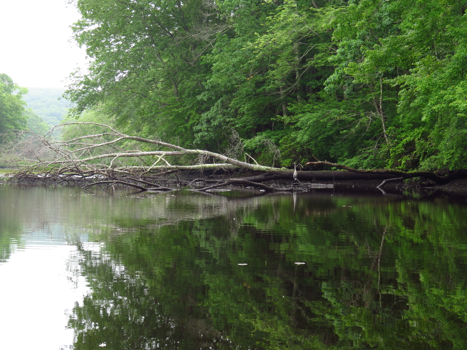
Just past the Filter Beds we had to wade knee deep in fast current for about 50 or 75 yards.  Fortunately, the bottom was good walking.  The river returned to a wilder self as we continued,  not that the current got faster, because it actually mellowed out some, but the surrounding forest became something deeper with the illusion of wilderness.  At the next fast section we were unable to bust the current.  The bottom was uneven - cobbles and small boulders and rather than wrestle with it - this was close to turn around time - we spun back.  

The paddle out was swift.  With frequent deadfalls to avoid, it was a good opportunity to teach M some new skills.  We worked on back ferries, setting the canoe up ahead of time and letting the river do the work and getting a feel for how the current moves or grabs the canoe. It's all about efficiency - working when you need to work, drifting when you can.  You can race down rivers like this at full speed, but you learn more by patiently picking your way through junk.  It's good to have that in your back pocket for when you really need it.

Sunday, June 13, 2021

The Jayfisher and the Rock Turtle

The weather arrived perfect with blue skies, temperature near 70 and a light wind, the predicted rain would hold off for another day.  We put in on the Lieutenant and paddled upriver and although the small launch area was close to being full of vehicles, no one seemed to be around.

By the time we reached the boulder swamp, which was well submerged with the tide nearing high, we had been regularly sung to by many unseen Marsh Wrens and quite a few bolder Red Wing Blackbirds.  We spotted a Jayfisher while passing through the swamp as we headed up the last half mile of the Lieutenant.  An Osprey in that area flew sentinel on us, circling and scolding until we left the nest area.  On our way back out the behavior was repeated and I figure that it must have some hatchlings in the nest.  Back at the Boulder Swamp, I spotted a rock turtle and S told me that she had just seen a Driftwood Heron.

With the high water, an exploratory run into Mill Brook was required.  There is an Eagle nest near the mouth, but it is a hard one to spot and we missed it on the way in.  The brook was in fine shape with enough water to get over the shallows.  There was a beaver dam in here, but it has been blown out.  Upstream of that was a fallen tree that I'd never managed to get past.  But, someone has cut a passage - probably last year by the look of the cuts.  We get another 200 yards before it turns to wading depth.  I'll come back on my own and see if I can get up higher to where there is an old mill pond.  Someone doing the work of cutting through that blow down is sign that there might be some paddling up there.

On our way out I spot the Eagle nest - it was a hard spot.  We don't see any activity, but this is about time that young Eagles can be left alone while the adults hunt (I'd seen the adults earlier this year).

We pass too many kayaks coming in as we head out.  I don't know how they get anywhere dipping their paddles like that.  They probably don't get anywhere.  Our timing was good.

Friday, June 11, 2021

Overdue

 I was sorting a few thousand canoe photos (in reality more than 10,000, most of which are junk because I often use the camera as a diary or binoculars) and I discovered that I hadn't been in the middle Scantic for four years.  It deserved a visit and my memory deserved a refresh.

I put in on from the bridge where Cemetery Road comes in.  It's a steep slippery 6ft high bank to access the water but with a grassy slope, I just slide the canoe into the water.  Then I head upriver. 

The Scantic is 38 miles long and never much more than 3 or 4 canoe lengths wide. It cuts through New England forest, touches a few towns and farms, but it is mostly well hidden in the trees.  In fact, it is quite difficult to locate looking at satellite images.  I don't know what the river looks like downstream of here except that where it dumps into the Connecticut River it is fairly choked with very large downed trees that are problematic to get past except when the big river is running quite high.

Right off, I have two short sections of shallow fast water to get up.  This is rock paddle water and my good hand carved paddle stays in the bottom of the canoe. A "rock paddle" is a reinforced thing, pretty much a good store bought paddle, but a bit of a club compared to my own.  Anyway, with a bit of extra exertion I 'm into the calmer water above.  Now starts a long meandering route in a 2:1 current with occasional extra maneuvering to get past dead falls.  This small forest river has a lot of large woody debris, but old saw cuts show that once in awhile someone comes in here with a chainsaw.  I stop once and pull out my bow saw to trim the top of a deadfall and open up a gap.  Otherwise, the river is as open as I remembered it to be.

I catch a good sized beaver sliding into the water.  I wish I'd seen it before it moved.  Then, a Great Blue Heron drops out of the tree tops and flies off.  Any exposed mud or sand along the shoreline is well tracked by animals.  It might be one of the best places I've seen for plaster casting tracks, but I don't have plaster with me.

After a short hour of upstream travel I come to more fast water.  This is more sustained with only short sections of pooling.  But, the water is shallow and the river gravel or cobble bottomed, so it is easy wading in less than knee deep water.

Then, the water slows down again but after a few hundred yards I come to a log crawl that I remember.  I keep going and get to the bigger log crawl that I also remember.  Both trees are bigger than the typical chainsaw, which also means they are big enough to stand on. But, this is just a few minutes short of when I planned to turn back, so I skip the lumberjack fun and head down.  The fast sections are easy, just lining the canoe up with the most open water and letting it go.  I pass the same beaver again.  It was basking again and once again I did not see it until it slid into the water.

I take out by climbing the bank and hauling the canoe up with the painter.  I am pleased to see that the river had not become choked with deadfalls.

Wednesday, June 9, 2021

Hunting the Illusion

 I put in at the end of the quiet forested cove. It is warm and still and I share the space only with a single fisherman.  I head out to the main river and when I get there one of those decisions made on nothing but a whim takes control and rather than heading down and around the point into another river, which is my usual route, I head up the Housatonic following the east shore.  I guide the canoe in close to the forest, this side being undeveloped full grown forest on a steep and rocky hillside.  I follow the sweet spot - where the canoe is under the farthest reaching tree limbs.  This lets me peer deep into trees, a motivational curiosity that I share with sled dogs - always wondering what is around the next bend or over the rise.  This edge between forest and river is where the life is. It is where you will find animals and interesting flora, it is where the Hawks and Eagles and Herons and Kingfishers and mink and beaver and otters are most likely to be found.  The edge of the forest hides at least a part of me from the built world and I live in the illusion of wilderness.

I take a short explore in the cove just below the four-span steel bridge.  I've ignored it in the past.  It goes deeper than I had guessed and gradually narrows until it becomes a small creek tumbling from the hillside. It was worth the trip.

Tulip Poplar Blossom
I continue upriver and head off into another cove that I've always ignored.  It is on the west side of the river and it too goes in farther than I expected.  It is, unfortunately, a bit too developed for my purposes, but now I know and I can pass it by in on future trips. I'm a bit glad that they tucked the houses in here out of sight from the main river.

I head back down following the west shore.  The heat of the day is starting to come on but I'll take out before it gets too hot.  My timing was good today.  I have had the river mostly to myself. In four hours I have seen only four boats.


Friday, June 4, 2021

The Illusion of Wilderness

Wilderness and wildness, I've written about the difference before but it is a topic that I revisit at regular frequency. Basically, wilderness is a place and wildness is a characteristic. Wilderness is always wild, but wildness occurs outside of wilderness. It has been a long time since I have been in wilderness, which is a term that we each must define on an individual basis... my idea of wilderness need not be your idea. There is no wilderness where I currently live, based on my definition. After all, with a compass I can walk a straight line and be out of the biggest local forest within 2 hours. Wilderness, in my mind, means being away from the man-made world such that not only am I self sufficient, but also insignificant with respect to my surroundings. This means no cell phone or other leashes to society...how can a place be wilderness if you can call in a helicopter rescue at the touch of a button? Many people will disagree with that somewhat harsh definition. Anyway, what I do is seek out wildness, something that a canoe makes surprisingly easy simply because water, swamps and effort cuts off a large number of the population. Add to that paddling on cloudy and rainy days or cold weather or when there is some ice on the water and the illusion of wilderness soon arrives. That is my wildness in this part of the country - the illusion of wilderness. 

I put in at Ely's Ferry. It is also, in case you were wondering, the high point of the 1814 British raid on Essex. Essex was a builder of medium and smaller ships and many of these were being used as privateers to raid and capture English flagged cargo ships during the War of 1812. A privateer is basically a government licensed pirate. The British had blockaded the main power of the US Navy in the Thames River, which is about 25 miles east of here. They sent a daring boat raid of 130+ men up the river and burned about 2 dozen ships at Essex. They shouldn't have escaped, but due to several military blunders, they returned to their ships in Long Island Sound with only the loss of two men.  By the way, the Ely house is at the mouth of Hamburg Cove and an Ely was one of the American officers that came to the defense of Essex.  Unfortunately, I don't know what the relationships are.

It took me two minutes to notice that Heron
From the old ferry landing, I headed up to the end of Hamburg Cove. The day was dark with a thick overcast, the Mai Tai Navy was restricted to shore and I had a quiet and pleasant paddle. In fact, the only noise was from a work boat preparing mooring buoys for the Mai Tai Navy. In a month, Hamburg Cove will be a large parking lot for the Mai Tai Navy (the Mai Tai sailors "park" their boats, they don't moor them). I mused about how if anyone ever wanted to go to war against the Mai Tai Navy, a cloudy day would be optimal as the entire fleet would be unmanned without any steam in their boilers, such as they are today. Early Monday would also be effective, hitting the Mai Tai sailors while they were still recovering from overdoing it with grog on the weekend. Returning to the river, I cut across the river and follow he shore down to Essex, then cut back across at Knott Island and return along the shore.

Wednesday, June 2, 2021

Doing the Wash

As often happens in these parts, I talk for several minutes with a guy who is using his lunch break to drop a fishing hook in the river.  I give him a few tips on other places where I see people fishing, which is about all I know or care to know about fishing.  Then, I put in and paddle downstream.

It is a pleasant spring day with a bit of sun and, at times, a bit of high thin overcast.  The wind comes up the river but only at a level that is perfectly described as a cooling breeze.  The tide is out but as I am ten or more miles upstream from the sea, the water is only a foot or so lower than normal.  After a mile I turn into the narrow Selden Channel.  The channel defines a reasonably large island, a long rounded hump perhaps two hundred feet in elevation and a mile long.  About three quarters of its circumference is guarded by a wide barrier of cattail marsh.  Except on weekends, it tends to be an isolated experience.

I find a new beaver lodge. It looks like a bank burrow that has been built into the typical conical lodge.  The older lodge a 1/4 mile downstream has collapsed.  This is probably due to someone trapping that colony.  It seems to happen often in here.  I am not amused.

New beaver lodge
It seems to be a day to do the washing.  Aside from the usual bird life - a Great Egret, a few Great Blue Herons, some Vultures and the expected Osprey, there is little to draw my attention from the paddling.  Most of the side channels are shallow, but the Elf Forest has enough water to enter.  I haven't been in here at low tide before.  There is at least a foot of water and enough width to turn the canoe around, so it works.  It is one of my favorite spots in the channel, loaded with stunted and twisted trees and swamp grass hummocks.  I never see anyone else in here, probably because people tell themselves that it doesn't go anywhere... but I've learned that all places take you somewhere.

Entrance to the Elf Forest
At the bottom of the channel I take a long wide turn out into the big river to avoid the 2 or 3 acres of sand bar that forms here.  Then, I follow the shore of the island upstream.  It seems a slog without reason - the current is slack and the wind is at my back if blowing at all.  I decide it's just a big water thing.   I prefer the smaller more intimate streams as there is always something in my face to contemplate.  On the flip side, big water gets interesting when it gets scary.

And with that, the washing is done.

Tuesday, June 1, 2021

Time


Rounding the point where one enters the Shephaug, I check my watch.  It is habit.  The first thing that I do when I set out is to check my watch.  Then, when I get to some significant geographical feature along the way, I'll check again.  The thing is that I can never remember what time it was when I started.  I might have started at 10:15, but it might have been 10... hard to say.  But, it is of no consequence.  That is one of the true beauties of the canoe.  Time is dawn, dusk, the wind arising, the tide, too tired to go on, or thunderstorm on the horizon.  Such are the important times to watch.

At the wide spot where I sometimes see Eagles, I scan the forested hillside - something like 300 ft of elevation - no Eagles.  Then a large splash to my left between me and the shore.  A mature Bald Eagle flies up out of the water after a failed fishing attempt.  It flies out ahead of me and perches, probably to shake its feathers, then it flies back to a perch over the spot where it was fishing.

The water is near mirror and without any chop the canoe speeds along.  Smooth water is fast water.  I note that the water is almost swimming warm and still clear enough that I can see bottom at 10 ft.  The other notable thing about the water today is that there are no motorboats.  I imagine the boat drivers to be hung over from a stormy Memorial Day weekend where they were trapped indoors with "nothing to do".

I spot Great Blue Herons every quarter mile or so. 

I spot my first brood of Wood Ducks for this summer.  The mother feigns a broken wing and flops off to the left.  Her brood, a double batch of 15 or so swims into the cobbles and does a good job of disappearing.  Wood Ducks often lay their eggs in another Woodie's nest, so a mother duck might find herself tending 15 or 20 ducklings.

In good time I reach the cascades and stop for a short rest before turning back.  On the way I pass another brood of Wood Ducks - maybe 5 ducklings.