Saturday, November 21, 2020

Charles Island

 We woke to a calm and beautiful fall day that was far too nice to waste and after short discussion of whether to hike or canoe, we drove the 5 minutes over to the town harbor.

As we set out the oyster boat "Risky Business" was backing into its slip and we chatted with one of the crew about what an excellent day it was.  Then, we paddled out passing a small flock of wintering Buffleheads who are feeding in the harbor.

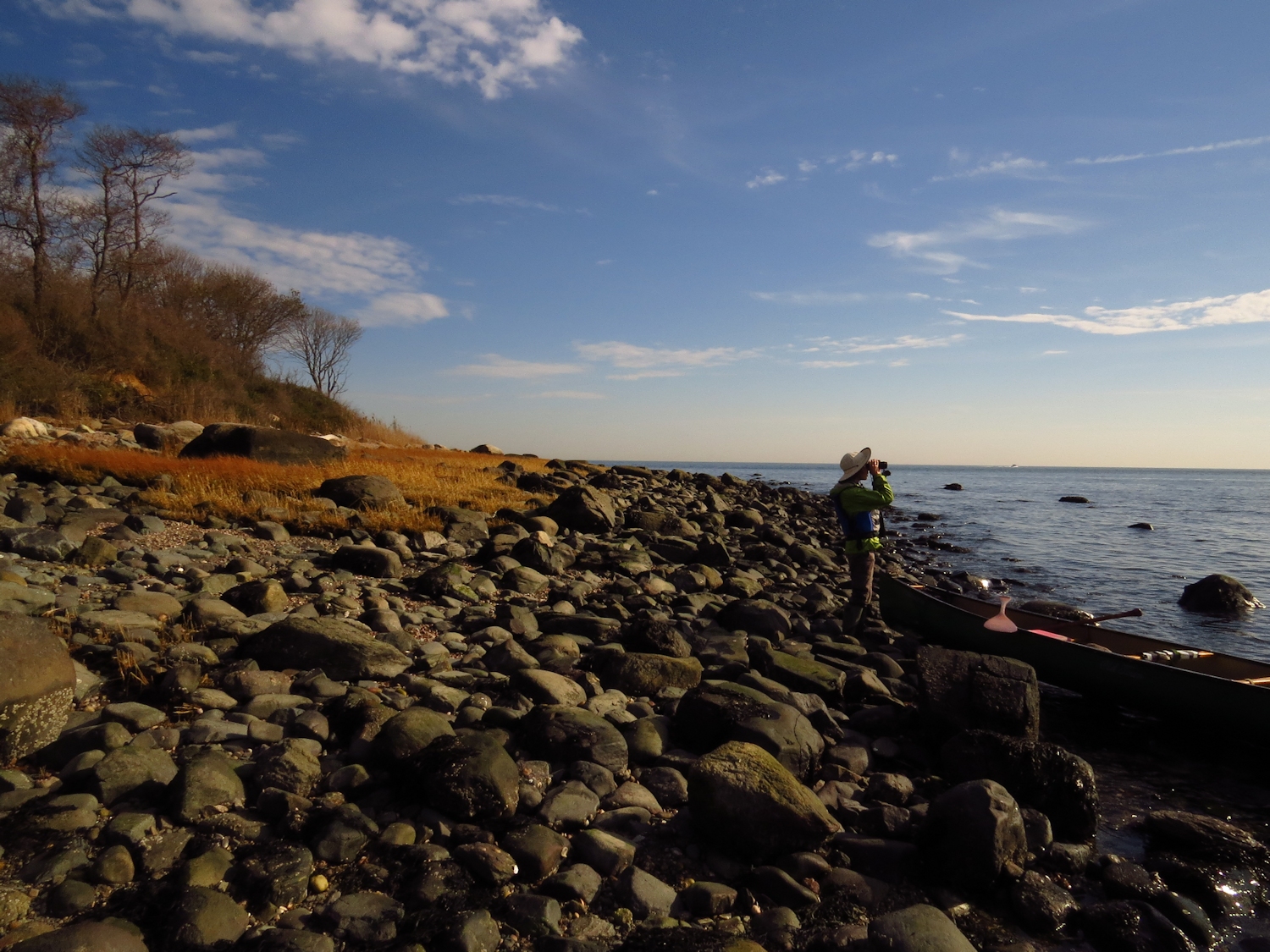
S scoping the Long Tailed Ducks

I suppose it had been at least a year since we'd visited Charles Island, and that last trip was by foot using the long bar that connects it to shore at low tide.  The water has dropped to the 50's by now, so for safety we turn and follow the shore, a longer circular route to the island, but one where we are mostly in or near shallow water.  It's winter paddling common sense, canoeing in 4 ft of water is not much different than paddling in a hundred feet of water except that it is safer.  Once at the bar, we follow it out to the island.  We pass a wintering Red-Throated Loon, smaller than the Common Loon with an obvious white throat.

Once on the far side of the island, I catch the calls of Long Tailed Ducks.  We beach the canoe and get out the binoculars and spot about a dozen a couple hundred yards out.  The constant chattering of the males is easy to hear in the calm air.

Then we finish circling the island and pick up the bar again for the return to the harbor.  S watches as a woman in an outrigger comes near and talks with us, "This is the first canoe I've seen out here, etc."  It's hard to describe, but we have little in common.  She wants to talk gear and gear isn't interesting.  This is primarily a workout for her, type A personality in pricey equipment.  Later, I comment to S that most of the people we meet canoeing are so much more aware of where they are - one of my favorite things about Connecticut.
Old Simon Lake submarine wreckage

Back in the harbor we take a short diversion to look at a small but heavy piece of wreckage.  Not long ago I found out that Simon Lake, an early submarine 20th century inventor, had beached one of his projects in the harbor where it sits rusting to this day.  I'd seen it from a distance and thought it was an abandoned ocean buoy.  It was worth the trip as up close one can see the complexity and sturdiness of the design.  It happens to be right in front the three houses that Lake built for his son and two daughters.


Wednesday, November 18, 2020

History Trip

November 17

The fall winds would let up for the day so I planned a canoe trip with a bit of history for M, who has a possible art project coming up in the town of Farmington.  

We started at the remains of the aqueduct that crossed the Farmington River.  In the United States, The ability and reason for building such canals developed just a few years before the development of railroads.  Except for short canals that bi-passed rapids or other impassable water, these longer canals quickly fell out of use.

Farmington Canal


The Farmington

I shoulder the canoe and we follow the old tow path for about 200 yards down to the river.  The stone foundations that supported the 50 foot high aqueduct remain on either side of the river.  I'm sure there are a couple of pilings in the river as well, but they were demolished well enough to not be seen, at least today.  The stone pillars stood until the mid 1950's when they were badly damaged in a flood and had to be taken down.
Aqueduct ruins

Recent rains have provided just the right amount of water.  I let M know that this is a 2:1 current and that our return trip will take half as long as our paddle upstream.

After a half hour M comments that the river lacks wildlife.  We talk a bit about patch ecology.  Some birds and animals like marshes, some like forests, some like rivers and others prefer the boundary where those patches meet.  Additionally, the birds and animals require a patch to be of a certain size before it is habitat.  In this case, the river is a patch, but the trees that line the river are not as those "woods" are usually only 10 or 20 yards in width with farms, golf courses or housing behind.  The trees are, however, an edge between patches, so it can be an okay place to spot birds that like edges such as Hawks.

We reach the old mill dam ruins in an hour.  The last 1/4 mile up to the dam is shallow fast water and we have to pick out the slower current and sometimes just places with water deep enough for the paddles.  It's a 50 yard portage around the dam remains and we put into the slower water of the old mill pond.

Up at the next bend we have the option of continuing up the Farmington, which from past experience is a bit dull, or heading into the smaller Pequabuck River.

In the Pequabuck

The Pequabuck was one of my first explores when I moved to this area.  It drains a large marsh, meanders often, and runs through low land that is unsuitable for development.  So, the quantity of bird life multiplies many times over what we'd seen in the Farmington and the comparative lack of tameness is obvious.  A half mile short of the second bridge (which is fast water requiring some wading) we pause for coffee. 

Our return is easy, our speed more than doubles as we ride the current.  In the mill pond we talk to the only person that we've seen today, a fisherman casting from a gravel bar - hoping for trout but expecting small mouth bass.  Then a quick portage around the dam ruins and a easy paddle down back to the put-in.

Tuesday, November 10, 2020

Draw Down

 I was surprised to drive into my launch point and find no other vehicles.  Then, I saw the water level.  I prefer to call this section of water, "river" although in some geographies it is a reservoir.  "River" is a species with much more life to it than any reservoir and I would just rather see it that way.  Anyway, the river was down a full 5 to 6 ft and I had stumbled on reservoir draw down.  This made my carry to the water an actual portage as I headed downstream along the bank to a spot that would not be a foot deep in boot sucking mud.  This, I assure you, was a small price to pay for the resulting solitude.  You see, the boat ramp ends about 25 ft short of the water, which is only two feet deep at that spot, and so it is quite impossible for anyone to launch a motorboat from a trailer.  I would see/hear no motorboats at all.


I headed down the narrower and shallower than normal cove noting a few large rock outcroppings that I've never seen above water.  There once was a railroad running along here and I note that one large outcropping is suspiciously spaced from the main bank by a gap that looks perfect for a rail line to pass through.  I need to spend some time with old maps to confirm that.

I flush a few Mallards, which seems to be the Duck of choice here.  Eventually, that count will hit about thirty.  The best sighting comes as I turn the corner into the main river.  A mink runs up the bank and hides away under the roots where the forest starts.  Its fur was quite dry and shiny in the sunlight, but it moved far too fast for a photo.  Most of the time when I spot a mink they have been swimming a bit.

This seems to be a wing dam rather than a wall section.

The newly exposed bank is mostly glacial till - rounded cobbles left behind by the last ice age.  Every inch of them is covered with zebra mussels, an introduced invasive pest species.  It reminds me of why I allows tell my guests in the canoe to wear tennis shoes and not sandals or flip flops.  I also note that aside from some stone wall remnants, there is nothing of historical significance on the exposed bank, which is no big surprise as the dam that holds the water back is 75 ft tall.

As I head up the Shephaug I flush a Great Blue Heron every quarter mile or so.  I hear a Red Tail Hawk on the far side of the river but I cannot get eyes on it.  I spot a few Common Mergansers, which all seem to prefer sunning on the bank to floating.

It is a warm and sunny day and I planned to go up far enough to see if I could spot where the old rail line comes up out of the river.  But, a tail wind comes up and I don't particularly feel like paddling into 10-15mph wind to get out of here. So, I turn back and soon find that the wind is not so bad, it is just being funneled into the valley at that point.  In fact, I paddle into a minor head wind back to the confluence, turn the point nearly 180 degrees and find myself paddling again into a headwind, and when I head west into the cove, it is a headwind as well.  

By the way, I did spot the "Red Tail Hawk" while paddling out.  I heard the call just to my left and looked over to find a Blue Jay that had perfectly mastered a Hawk call.

Friday, November 6, 2020

Menhaden University

M and I put in at the Feral Cat Park for a trip up the river.  My memory was correct that she had never gone upriver from here although we had headed in the other direction to visit the big marsh.  It is a spectacular warm and sunny autumn day and at least when we begin it is calm.  We turn the point out of the tiny cove and begin upriver on a flood tide current. 

At the first island we begin spotting Great Blue Herons.  By the mid point of the trip we will have spotted something between 15 and 20.  Before we get to the dragonfly factory we have spotted three Bald Eagles, two adults and one immature.  To that add some Kingfishers and a Sharp Shin Hawk.

It is an easy paddle with no boat traffic on the way up.  A wind starts to rise as we reach the second island.  We spot two Osprey.  Note that there are a good number of fish eating birds in the area today.

Figuring the wind and tidal current I decide to take a turn around Wooster Island and head back.  By this time we have solved all of the world's problems, so there is no need to paddle farther.

An almost excellent photo of a Kingfisher

The wind does not disappoint and the return trip is a power paddle grind and I try to steer us into the wind shadow whenever one exists.  We follow the west shore for that reason.  When we get down to the first island I notice a very large school of menhaden (also known as poghaden or pogies).  It is a sardine type fish that filter feeds in large schools.  They have a forked tail and often hang out right near the surface. I usually spot them in groups of 30 to 50, guessing by the tail fins sticking up out of the water.   But, this school is as long as the island and half as wide as the river.  We head across and paddle through the school.  As the canoe approaches they dive or move out of the way splashing the surface.  It looks a bit like a piranha scene in a B-movie.  We both agree that it is exciting to be surrounded by so much life.

Menhaden tail fins

Anyway, as we paddle down the east shore we can see that the school is much longer than the island.  In fact, it runs almost to our take out point, which means this school of menhaden was over 1-1/3 miles long! 


Thursday, November 5, 2020

The Miracle of Fluid Dynamics

 I set out on the big river, a leisurely start due to the timing of the tide.  With about 3 hours to go before high tide, I set out don river against a stiff flood tide of 1-2 miles per hour and a 10 mile per hour headwind.  It was power paddling down to the bridge.  On this side of the bridge, through the miracle of fluid dynamics, the current runs stiff bank to bank.  I suppose some of this has to do with the tide being directed through the bridge abutments, but I could just be blowing smoke.  The first pause is in the eddy of a bridge abutment.  The current eases some below the bridge and it lets up a bit more near shore.


Beaver Creek
Entering the marsh, the current reverses.  The direction of a flood current in a big marsh is usually, in, as opposed to up river or down river.

I start with a diversion up Beaver Creek.  The birds today are mostly ducks.  I flush a dozen Black Ducks either as singles or pairs, no flocks.  I spot a Great Egret and good distance circling the edge of the marsh and a Kingfisher and an Osprey as the creek narrows.  At the last main bend of the creek before where it becomes too shallow, I slush about 3 dozen Mallards.  

I circle the marsh clockwise noting little in wildlife but enjoying a sunny autumn day.  The spartina has all gone gold, but it stands high as it will until we get heavy snow.  From Milford Point I follow Nell's Island Channel back upriver riding the tidal current with the wind at my back.