Sunday, September 29, 2013

The Millpond

It is nothing but delightful even before putting my canoe in the water.  The millpond is just beginning to surround itself in autumn colors, the trees showing reds and golds mixed in with the greens of late changers.  An abandoned red brick mill is across the way near the dam that once gave it power and held (and still holds) the water at a constant level.  I greet two older guys who have brought their newspapers down to the waters edge and a couple that is killing some time waiting for a baptism service to start at a nearby church.  It is an exceptionally fine morning.

Somersville Millpond

I start by paddling the millpond, which is far from being round.  Instead it is a long pond with several arms radiating out and edged with trees, high shrubs and a narrow marsh of cattails among other things.  Having determined which arms are dead ends, I head upstream on the Scantic River against a barely perceptible current. The river has its own dead ends and sometimes at these junctions, the main channel narrows and the decision becomes a guess.


I may not get far today, I am using my camera about as much as I am using my paddle.


Scantic River
The river continues to narrow, and with it comes more and more deadfalls laying across the water.  Most of these require nothing more than standard canoe contortions to get around or under.  I stop to admire a tree that has been half cut by beaver.  If they haven't abandoned the project, it should be down soon.  I always take beaver sign as a good omen.

 
I hear rushing water around the bend - the sound of a small cascade or dam.  I find a solidly built beaver dam, some two feet high and built using a large tree that had fallen in the water, the beaver adding branches to the 20 inch diameter trunk.  I get out and slide up and over it on the right end and enter a beautiful and fully developed beaver pond.  The millpond was nice, but it had nothing on this.  Standing dead trees, drowned by the increase in water depth are surrounded by what seems to be the most diverse collection of plant life that I've seen.  In this setting, the idea that beaver do damage reaches absurd.  Here, by building a simple dam across the river, they have created a unique and stunning botanical garden unlike any other.

Beaver Dam


Beaver Pond
I continue on and for the first 300 yards, I lose and refind the main channel more than once.  It's easy to see, once that you've seen it, but seeing it in the first place is the hard part.

Beaver Pond

I continue up the river at least as far as I have already come.  It stays narrow and deadfall contortions come with regularity but the river also meanders very tightly, at times nearly doubling back on itself.  I turn back just short of two hours out when houses begin to appear on the banks. 


Almost back to the millpond, I find a heavy earthware jug on the bottom and retrieve it by pushing it to the shallows with my paddle.


Wednesday, September 25, 2013

Five Brants, Five Loons - going where they end up

I started the morning by reading a few articles in Minnesota Conservation Volunteer, a magazine put out by that state's Department of Natural Resources.  How lucky I was to grow up in a state that valued its environment.  In retrospect, what I do is not something that I came across by luck, but instead, a result of many seeds planted by many different people, people who hoped that something would grow, but knew, in most cases, that they would never get to measure the result.  True to my nature, I don't seem to have been involved in making the plans....I go where I end up.

I put in down in front of the house on a cloudless day if one excludes the ones that are way over on the east horizon...where I am not going.  A half moon still hangs overhead and a fine cool autumn breeze blows off shore.  The tide has just passed low and I can start from the minimal shell beach that shows at that water level.  I stay reasonably close to land, mostly for shelter from the wind but also because the water is beginning to cool off and in the event of a capsize I'd rather not be drifting farther from shore.  Rather than cut across the bays from point to point, I swing in, paddling extra distance knowing that this will delay my arrival at the mouth of the river, which just might make it possible for me, as the tide comes up, to squeeze through a gap in the breakwater instead of paddling the mile out and around it.

I portage the bar that leads to Charles Island.  It is awash, but only by an inch.  The portage is not much more than 15 feet and hardly counts as such.


It takes something short of two hours to get to Milford Point, at the mouth of the Housatonic.  I do, in fact, find a gap in the breakwater that lets me sneak a shortcut into the river.  There, I spot 7 swans with 5 brants and a bit farther off are 5 loons.  The loon calls are limited to a brief "hoop".  One surfaces 20 feet away, very close for a loon.  I wonder if they might be yearlings here for the first time.  They aren't particularly large and seem a bit too curious for loons.  They are common loons stuck somewhere between youth, adult, summer and winter colors.

Milford Point and the Wheeler Marsh


I stop inside the point to stretch my legs and eat some lunch.  There is barely enough water to pass through the deepest of the channels in the Wheeler Marsh, but it will get deeper on the flood tide if I run out of water.  The mud banks at the base of the tall spartina grass are exposed and as a result there are quite a few birds out feeding.  I pass 20 some swans, see many egrets, several of the night herons, a great blue heron, some lesser yellow legs, and something small, dark and very fast hunting other birds (I hear a lot of warning calls when that bird comes by) but I can't identify it.

a juvenile night heron

I've never been in here when the water is this low...the yellowing grass being well over my head, it seems like... paddling through prairie.


Link to Minnesota Conservation Volunteer Magazine

Thursday, September 19, 2013

Back in the Salmon River

7 Cormorants
68 Mute swans
5 Great blue herons
7 Bald eagles
16 Canada geese
1 Osprey
1 Kingfisher
4 Mallards

Mouth of the Salmon River


I don't stop until I reach the Leeville Dam, although I do not make that four miles with any sort of diligence.  When I roundedthe first bend, which is where the river opens up into a broad cove, I spotted some cormorants, an immature bald eagle and a large flock of swans.  Strewn over the water ahead of me, for perhaps the next mile, were thousands of swan feathers, white and clearly visible on the calm water.  I zigged and zagged grabbing as many of the feathers as I can, because I have a plan for them.


The river has houses, but many are tucked back in the forest, all but invisible to me, a design for living in nature that I highly approve of.  Where there aren't houses, and there is a great amount of shoreline that fits that description, small signs show the land to be National Wildlife Preserve or State Forest or Nature Conservancy parcels.  Some of that is the "no admittance" type of National Wildlife Preserve, a benefit of a former atomic power plant that no longer graces the skyline.  As much as I might like to walk there, the fact that it has become wild because no one can is satisfying from the seat of a canoe.  The river is notably quiet on this windless morning...a buffer of forest and hills between here and any main roads.

The Leeville Dam was built on the site of a waterfall in the 1860's.  It now has a fish ladder to help with recovery of Atlantic Salmon and a few other fish species that were strong enough to clear the falls going upstream.  The portage past the dam is nothing difficult, but today I'll just pass on that.  I stretch my legs getting the lay of the land and then return to the canoe.  I passed a few turns and bays and inlets and marshes and tributaries on the way here and I want to explore them on the return.

In a freshwater tidal marsh, the flowers go swimming

It is the last tributary on the way out, one that heads of easterly, that is most interesting.  It is the "tunnel of water through the trees" - a favorite type of stream for me.  The shading trees enclose the stream in a leafy canopy and the water has no straight sections.  What is ahead is always around the next bend.  I could take a hundred miles of this, but that never seems to happen, and I take what I get.


At one point, I catch a nice sweet scent, but can't place it and find no blooms in sight.  I continue until about 3/4 of a mile in the stream becomes a very shallow cobbled flow that won't float the canoe.  As I return, I stay alert hoping to find the plant attached to the scent...and I do.  They are feral grapes (possibly concord), and not having had wild grapes before, I bite into one as I would a grocery store grape.  It is good, but has several large seeds that surprise me.

Feral grapes


Tuesday, September 17, 2013

Post Nuke Wildness

I tried Essex, the historical boat building town come tourist town, but the water there is broad and open and there is too much wind and too little shelter for a prudent start to an enjoyable canoe trip.  So, I head a few miles upriver to the town of Haddam where the river is narrower and held between wooded hillsides that soften the wind.

Last night, the temperatures dipped into the 40's, the coming of fall for sure.  But that coolness takes the summer humidity from the air and combined with the day's bright sun, it leads to brilliantly clean landscape views with intense colors and deep contrasts.  It will only increase as winter comes on and the sun stays lower in the sky casting the long shadows.

Connecticut River


I cross the river to the opposite bank where the trees on that shore have almost stilled the wind, and I head downriver looking for the entrance to the Salmon River, just to see what is there.  The first cove is blocked by 15 orange floats spanning the gap, "Access Forbidden" and "Federal Law ...." painted on them.  I continue hoping that that wasn't the Salmon River.

the tip of Haddam Neck


The land inside the bank slowly lowers, becoming swamp, and in another 1/2 mile I find the turn.  The river starts out a hundred yards wide, but gets wider as I paddle.  There is no firm shore, at least at this tide level, instead between the water and dry ground is 50 or a 100 yards of low swamp with bent and stunted hardwood trees and plenty of silver dead snags.  I spot three osprey nests, 2 natural and one a platform, but no ospreys.  I turn the first point and find more than thirty swans, half strung across the river and the other half flocked together.  I'm still a couple hundred yards off, but I hear the whistle-fart call that identifies them as mute swans.  I spot a few houses, but only when I get near to shore, so well hidden in the forest.

Salmon River


The river continues quite a ways from here, but unfortunately, geography has set the wind straight down the valley.  It's not making waves, but skimming over the surface.  It is a beautiful spot worth returning to on a calmer day and having that knowledge, I turn back.

Returning on the same east shoreline, I have time to wonder about the prolific no trespassing signs that probably go along with the orange floating barrier.  There is a sign damn near every 10 yards, sometimes two or three on adjacent trees...no mistaking the intent.  Once I pass the swampy section, there is a large flat open meadow area above the bank, but it is too high above to actually see.  There is a high tension power line dropping down the hill but not leaving.  A truck drives past, so there is a road.  I spot a concrete building back up against the hill.  With that power line, the only thing the Federal Government could be doing is attempting to duplicate the experiments of Dr. Frankenstein, unless they are building nanorobots... but that's two possibilities.

When I get home, I search some and find out that it was the Connecticut Yankee Atomic Power Plant, decommissioned in 2004 and most impressively wiped away since then.  So, they were doing Frankenstein work, but they've stopped.  They've also left a good long stretch wild and undeveloped shoreline to paddle along, even if you can't hike on it.


Saturday, September 14, 2013

Feeding the Wild

Yesterday was supposed to be windy, but that never happened.  Instead,  it rained for 20 minutes or so every two or three hours and I ended up staying in and working on things.  I told S that I would get up early today and go inland to smaller water.  While I didn't get up particularly early, at least for me, I did go inland as yesterdays winds arrived this morning and starting out on the ocean would not work.

I started by heading down river because I hadn't gone that way before and I like having a knowledge of the lay of the land.  There is much more current below the put-in than above it and the river isn't as wide as I expected.  It's a lot of weaving around woody debris - snags, deadheads and downed trees and it might be easier if there was more water.  I get the main idea and I turn back short of a mile.

I pass the put-in heading for the Great Swamp as a group of first time kayakers twitch their way into the river.  This is a good spot for them - not much trouble to be had and a river that is often less than waist deep.

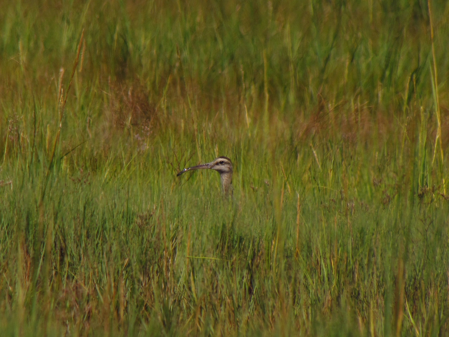
I spot a great blue heron perched low at the edge of the water about 200 yards off and think about how it is possible to make such a sighting.  This time it is geometry - a shape that isn't quite right for where it is, a stump or stub of a drift log that is all the wrong shape.  Sometimes, as with a kingfisher, the presence is announced and the sighting of it follows.  It reminded me of a time when I was berry picking in the mountains.  I stepped out onto an old logging road and froze knowing that something was wrong but I was not able to see it, a disconcerting feeling to be sure.  It took several seconds before I made out that about 60 yards away was a bow hunter in a camo gilly suit...who had also froze in position, I suppose to test his gear on me.

The lightning tree
I stop briefly and greet the lightning tree.  It is a burned tree and the only tree in sight with any burn marks on it and it stands in ground that is permanently saturated.  I can only figure it to be a lightning strike.


I meet two kayakers who tell me I can only go another half mile because of a beaver dam, but that isn't true...it's much easier to negotiate a dam with a canoe than with a kayak. And, it means that no one else has gone above that point in the river and an creatures that were there this morning are still there.

The dam was nearly flush on my last trip, but this time there is 2 feet of difference across it.  I get out near the bank and make an easy crossing over the top.  The lodge that stands just 10 yards away is small but neat and nicely symmetrical with the dam formed in pleasing curves.  I notice that the upstream water is as deep, if not deeper, than on my trip here earlier in the summer.  The beaver have a good dam.

First beaver dam with lodge behind on the left
At the first log crossing, which I remember well because of the gymnastics involved in getting through and past it, it is clear that the water is up a couple inches.  Here the river is in the woods and the banks frequently show game trails.  I spot a couple beaver scent mounds as well.  I take a wrong turn at a fork that I do not remember.  The fork peters out after 200 yards, but it pays off as on the return I catch the scent of castoreum (beaver musk), which I haven't smelled since leaving Seattle.

The log crossing section goes easy this time, just two exits from the canoe, the last and worst log jam having been breached at the bank by some nice person.  Then, I pass under the road, one of very few roads that cross the swamp, and enter the next open sky swamp.  I cross a second beaver dam that at its lowest point is only three or four inches high, and I take a wrong turn into a backwater where I find lodge belonging to the dam.  It is large, perhaps 5 feet high, and well hidden from the river due to shrubs growing on that side.  I missed completely it last time.


The third dam comes soon after.  It is a foot high, but I have gotten what I came for and don't need to cross it.  I've seen no one for a couple of miles and could probably sit here for the next week and not see anyone else.  I sit and enjoy the wildness.

Friday, September 6, 2013

The Multidimensional Environment

I paddle all of the way to Cedar Island before seeing a willet.  On all of my earlier trips I would have seen ten or twelve, at least.  Whether they have migrated or are just back in the marsh where I can't see them, I can't say.  I haven't been here often enough, or often enough over a long enough period to know.  This is a multidimensional environment, this salt water marsh/tidal river.  There is day and night, the seasons of the year, two tide cycles per day, and the unscheduled events - weather and storm surges, and the long time constant event - climate change.  I know day and summer, and I know high, low and mid tides and sun and rain.  If you do the math, that's not very much considering all of the possible permutations.

Today, I started with the water high, about 90 minutes of flood remaining.  The mud banks that many of the shore birds feed on are submerged.  But, this puts me four or five feet higher in the landscape.  I can see across the broad short grass wetland, an expansive view that is not there at low tides, and not all of the marsh birds feed at the river bank.  After I leave that one willet behind, I spot the head of a whimbrel with its unmistakable long curved bill.  There's another, and two more, and another.  They're back in the grasses feeding, poking their bills into the mud.  It's a favorite bird, one can't help liking it just because of the marvelous evolution of that improbable bill. 

Whimbrel


But, these observations are just passing ones.  I timed my start so that I could access the upper reaches of the river and I have a bit over three miles to go to get there.

At lower tides one can paddle upriver about three miles, maybe three and a half at a mid tide.  This will get a canoe to the edge of the forest where the river narrows.  I've been there once before.  This time, the river has a few more feet of water in it.  It is calm and deep enough so that my paddle doesn't touch bottom.  I turned around on that previous trip just below a thirty inch diameter tree trunk that blocked the river.  It is nowhere to be seen this time. 


The river narrows more and the bends become very sharp.  I thread my way through partially downed trees and guess at which channel to take around several small and temporary islands.  I don't have to get out of the canoe until I come to a bridge (the 6th bridge up from the ocean).  I chat with a fisherman there.  He lives nearby and is surprised to see me...doesn't think I can get much further.  He's right.  The river bend narrows more and climbs, the water ahead just a few inches deep and not going to get any deeper without an even higher tide than the one I rode in on. 

Great Blue Heron


On the way back, I come across a flock of 82 Canada geese that weren't there when I came upriver.  I try to make a shortcut from the river into Bailey Creek through and old drainage channel, but the channel no longer runs the distance.

Touch-me-not (at the turn-around point)

Tuesday, September 3, 2013

The Child of Nature

I started the day down, thinking too far ahead in life and daunted by the work ahead.  Sometimes one needs a reminder of why they are here.

I carry the canoe down to the ocean under a heavy thick and humid sky where the clouds are so laden with moisture that it can't all stay put.  An oysterman working his allotment provides the only noise, his well muffled engine thrumming five hundred yards out.  The town looks asleep and the gabled houses that crowd the shoreline seem to be two hundred years old when seen from a distance through the murk.  Of course, nothing built that low and that close to the water could last so long.


A third of the way to the flag rocks, it begins to sprinkle and I put my camera away.  Then, I hear static approaching from over my shoulder, and in a few seconds the front line of a rain squall sweeps by me.  It dissipates in a couple minutes.  I hear some thunder, but it is very far off, probably well over Long Island.  Not two hundred yards further and I hear a louder static with a much richer tone coming from behind.  It is a momentarily eery experience.  Again, a line of rain sweeps by, this time with heavy cold drops.  The surface of the sea dances in white splashes.

I drift into the Oyster River on the last ten minutes of the flooding tide.  I notice immediately that I am flushing more ducks and since it seems a bit early for migration, I decide that these are probably ducks that were hatched nearby this summer showing off their new flight feathers.  Five snowy egrets and two great egrets are perched on the downed tree.  I'd like to explore the third of a mile above them, but decide not to disturb them.  I edge up against the bank and just watch.


Heading back out, I notice that there is a good current running under the very low bridge that I've never bothered to slip under.  This amount of flow indicates more than just a wet spot on the other side.  I duck low and slide through finding a good channel that runs a third of mile back through a spartina marsh before petering out as a shallow well-treed creek.  I flush 20 ducks, several snowy egrets and two hard to identify herons.

The great egret has a yellow bill, the snowy egret has yellow feet

I return home, paddling a calm sea, weaving through the flag rocks without disturbing the oystercatcher.  I return home, my child of nature refreshed.


Sunday, September 1, 2013

Bailey Creek Bird Television

S and I get an early afternoon start putting the canoe in on the East River sometime before a not-too-low low tide.  The possible rains have held off and the sky is overcast with a light south wind, and it is sticky humid.


The Neck River meets the East River just about a hundred yards upstream and we take the Neck since S has not been there and I found the bird watching to be very good on my last trip.  Before we get to the first bend we spot two short billed dowitchers, a cormorant, several osprey (most with fish in their talons), a marbled godwit, a black bellied plover, several least sandpipers, and as usual, quite a few willets.  I tell S that I feel spoiled by this area - there is so much happening and at such close range that it feels like I don't have to work for the reward.

short billed dowitcher

When we get to the where the Neck and Bailey Creek meet we choose the creek, which is new water for me.  The bird life drops off some with the banks growing the tall spartina grass, a native but it blocks the sight some.  The creek meanders for at least a mile.  It is longer than the Neck and maintains its depth almost to the very end where we get to watch a young snowy egret feeding on a mud bar.  They shuffle their yellow feet (it looks like they are wearing rain boots) one at a time in the mud to stir up food critters and this is egret is unusually tolerant letting us drift by at twenty feet.

 
black bellied plover

marbled godwit