Saturday, August 31, 2024

The Naugatuck Flush

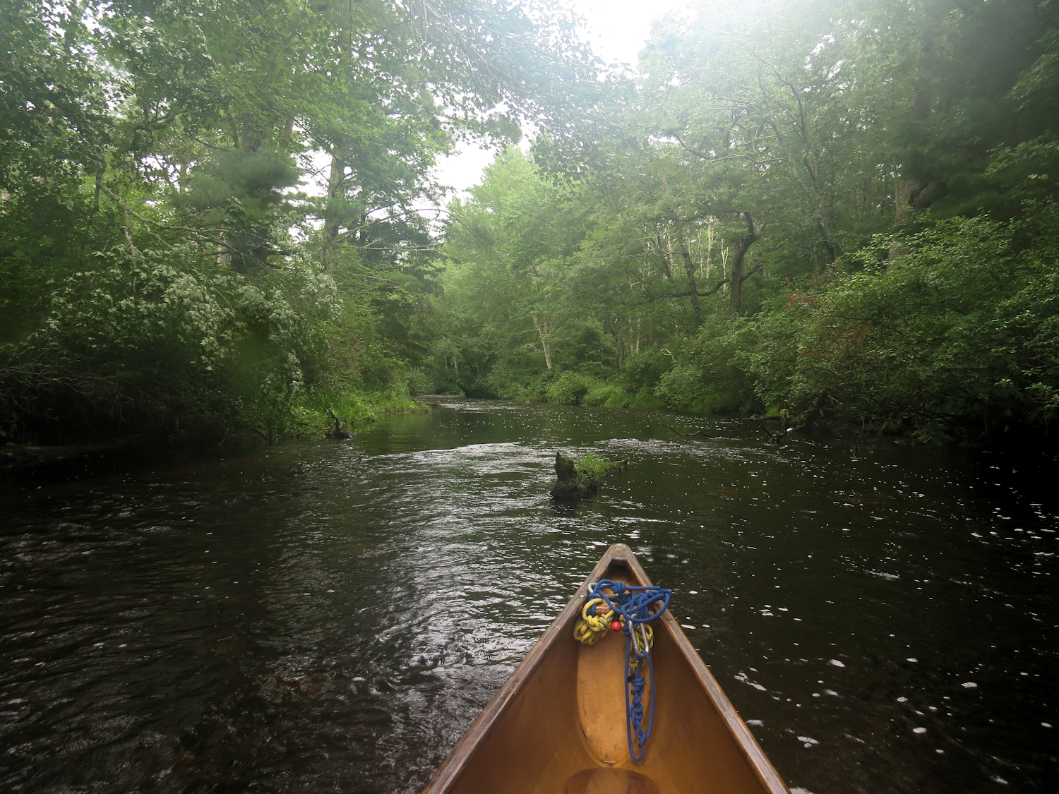
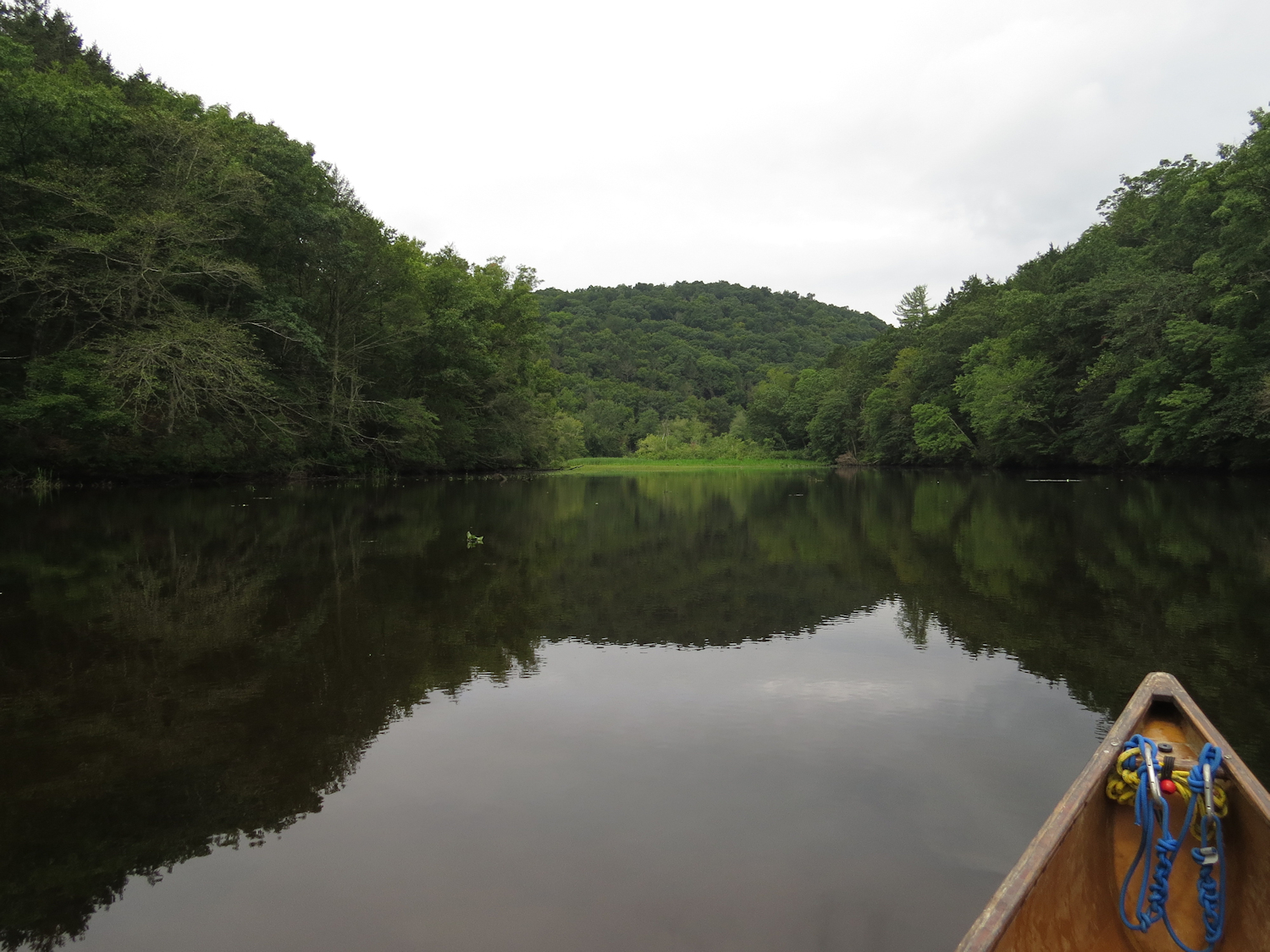
It is too nice a day to not go canoeing. I put in under the bridge on the big river on the far side of town. The tide is close to peaking, so I head upriver and will take advantage of the extra downstream push as the tide drops. 

I cross over the river just above the railroad drawbridge. The engineer in me enjoys looking at old school constructions where I can visually assemble the parts and load paths that keep such things in the air. I head back into the Quad Islands taking the narrow channel between Carting and Peacock, as I usually do when I get the chance. There is a lot of trash in the water and I figure quite quickly that I could fill my canoe without leaving this set of four islands. But, I can also fill my canoe by paddling upstream a couple miles and back.


I've noticed that after heavy rains, the Naugatuck River flushes large amounts of trash. About 8 miles upriver, that river joins the Housatonic, and if one happens to be at the confluence after heavy rains, the difference between the two rivers is obvious. It might exceed a 50:1 ratio of junk items with the Housatonic being surprisingly clean. Almost two weeks ago, there was a tremendous although localized downpour in the river valleys upstream from here. It looks like the trash stream has finally arrived, and it's not just bad, it is the worst that I have ever seen. 

I have my own ideas as to why one river flushes so much more trash than the other. The Housatonic flows through a lot of farmland and forest preserve lands with a few towns. It is also constrained in a few large (for this part of the country) reservoirs. Meanwhile, the Naugatuck runs through a series of old mill towns and one good sized mess of a mill city, Waterbury. The river is situated in a deep valley that it shares with a substantial state highway. I wonder if there are a series of point sources for the debris. It's easy to blame Waterbury, if you've ever been there, but it's probably not the whole problem.

I "opportunity" collect trash, grabbing stuff as I paddle nearby. I only go out of my way for the inflatables, which today are 2 beach balls, 2 inflatable buoys, and one of those rafts that get towed behind a motorboat. There are two reasons to get the inflatables. First, they are particularly unsightly because of their size. Second, I get to take out my frustration by stabbing them with my knife. There is something nice about hearing them wheeze as I crumple them up in a ball and toss them into the bow of the canoe. Another good find is an almost new horse-collar pfd. I'll cut it up and salvage the straps, foam and nylon shell. It's debatable, in my mind, whether horse-collar pfds are beneficial in general. While they will save a life when worn, they are uncomfortable as well as being most peoples first experience with a pfd. My guess is that most people don't wear pfds because they have decided, unfortunately, that they are uncomfortable and bulky from the experience of wearing a cheap-ass horse-collar pfd. A cheap horse-collar is a $15 item, and a basic comfortable vest that someone is more likely to wear costs just $10 more. And, pfds are pretty useless if they aren't being worn when you need them.

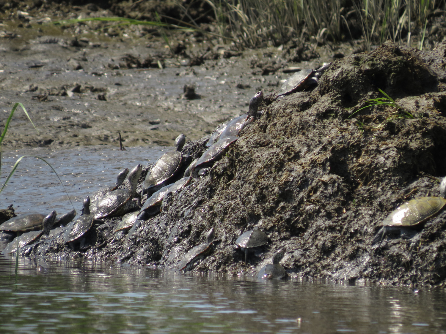
I return back through the islands, riding a nice current. Spot several young Night Herons and a few Great Egrets in the back channel.

Friday, August 30, 2024

Beaver Creek

We put in on the big river on the other side of town. It was a surprise to find the water pretty much to ourselves being that it is a Labor Day Friday with perfect weather other than some wind. 

The tide is still dropping but I figure that the current will fall off some by the time we head back from the marsh. The wind is out of the east, so we will have some protection as long as we don't venture out into the middle of the marsh.

"Night Heron, straight ahead in the branches"


We spot a couple Night Herons as we reach the top of the marsh. I steer us into Beaver Creek. I haven't been in here for a couple months, which is a sideways excuse as it is well sheltered from the wind. We flushed a Green Heron on the way up, and then where the creek bends north, we start flushing Night Herons. It is young birds and mature Yellow Crowned Night Herons, although the young ones are probably Yellow Crowns (you have to look close to differentiate young Yellow Crowns and young Black Crowns. There are also a couple Osprey in here.  We turn back when the water gets thin. We've seen about 15 Night Herons.

We head out of the creek and take a quick look up one of my inner secret channels, going until we run out of water. I'd like to go see if we can sot some Clapper Rails, but it's just too windy to go up Nell's Channel, where I've been spotting them on the last couple trips.

We head back up river jumping eddies by hanging near the shoreline.


Tuesday, August 27, 2024

Chapman Pond

When I got there, I found that an army of kayakers had set out from the Lieutenant River, so I headed up to Lords Cove, but the put-in was being resurfaced, so I went to Hamburg Cove, but it just didn't feel right, so I ended up under Gillette Castle at the Haddam Ferry, where a small army of kayakers were just setting out. They were heading, almost for sure, downstream to Selden. I put in and headed the opposite direction.

It has been a couple years since I did this stretch and I was overdue to check in. I follow closely the cliffs of the Gillette property (now a state park). Gillette was a 19th century stage actor famous for his portrayal of Sherlock Holmes. The deer-stalker hat and pipe were his ideas. Besides the weird grotto castle, he had a miniature train that took visitors all over the property. Following the cliffs, I can see remnants of trestles that were built on the cliffs. Some of those remains are in the water.
Exiting Chapman Pond

The cliffs give way, dropping some in height and moving back from the river to be replaced by an extensive swamp. Osprey are numerous enough that if you don't see one, you only have to wait a minute and one will show up. I spot a mature Bald Eagle, which takes wing and crosses the river.

I head up through Chapman Pond. The lower entrance is the original natural channel. It meanders in through swampland. The banks have some wild rice and a good amount of wapato. Then, I paddle about 1/2 of the way up the pond before taking a man-made channel back to the river. This channel was supposedly dug by some 19th century shad fishermen who were upset by a landowner who wouldn't give them access to the pond.

Northern Harrier

Swing Bridge and the Goodspeed Opera House

Exiting the pond, I flush a large mature Bald Eagle, then turn up the shoreline up towards the Haddam swing bridge. An Osprey and a medium sized Hawk are perched on the end of an island just off the exit channel. The Hawk appears to be a Harrier. I usually see them in bigger open marshes. Spot a Green Heron and a Great Blue Heron as I go. At the bridge, I cross the river and follow the west shoreline back. 

Wild Rice

I cross the river again, just downstream of the ferry route, and head into Whalebone Cove. The road that led to my put-in runs along the side of the cove, and I noticed right away that most of the cove is full of wild rice. Apparently, I have only paddled here in the off seasons. I headed in to the cove to check on the crop. The plants are unusually tall, as this is a tidal freshwater marsh, and right now, the water is down more than a foot below mean. The grains aren't ready for harvest, but this would be a good spot to come during a high tide if one were inclined to do the work necessary to process wild rice.

Exiting Whalebone Cove


Monday, August 26, 2024

Clapper Rail Chicks

I don't get started until the middle of the day. It feels warm at the house, but I go anyway. And, I am glad I did. Once I am in the canoe and down in the water, the heat of the day disappears. I head down river with a light fresh breeze on my face. It is sunny with tall cumulous about the horizon indicating that the weather service prediction of early evening thunderstorms might be accurate. 

On the way down river, I see a jet skier slowly circle a big floating object. I would've passed it assuming it to be driftwood, but now I have to go look. It's a dead beaver, most likely a casualty of the flash floods a week ago Sunday that were higher up in this drainage. Anyway, the beaver is a week dead and just about at the bursting point.


Low tide was about an hour ago, so there isn't too much current, yet. When I get to the top of the marsh, I head up Nell's channel. The Osprey are about, but my sight lines are short with the low water. I spot a pair of small Clapper Rails up one of the side inlets. Stopping to observe, a third comes into view. 

Clapper Rail Chick

These are young birds, small and dark gray with downy feathers. I continue down and spot another young Rail about 200 yards away. About another hundred yards, I spot an adult Clapper Rail, and then a second one on the opposite side of the channel. That's 4 Clapper Rails for my lat trip here, 6 on this one, and I go whole years without seeing any. Birds become more seen for a variety of reasons. Sometimes it is the migration, or with some birds it's nesting. Some will show when the migrate in and then disappear until their young fledge, and then they're back where I can see them. It looks to me like my sightings are matching up with the end of Clapper Rail nesting. 

Dowitcher

I head down to Milford Point. I've gone just slow enough that there is enough water to paddle the circle route around the marsh. In the lower east corner, I spot three Black Bellied Plovers. I had hoped to see Clapper Rails, but I did not expect to see Plovers. 

I skim through the shallows and turn upriver along the wooded east shore. I spot a Dowitcher near Cat Island. Other birds for the day are several Snowy Egrets, a few Great Egrets, a few Yellow Croned Night Herons. I'm sure there are quite a few Night Herons out in the spartina, but with the low water, I can't see them.

Saturday, August 24, 2024

The Black Hall River

S woke up and decided that we should go canoeing. Our drive coincided with a massive traffic jam. People that live in the greatest city in the world spend great effort to get out of that city all summer long, go figure. 

We get off the long parking lot well before our intended destination and, instead, put in from Neck Road near the mouth of the Connecticut River. The extra time in traffic and wandering around has played to our advantage and we have a rising tide. A small fleet of plastic kayaks and paddle boards arrives, but I know well enough that they won't get very far from wherever they started. We turn and head up the Black Hall River.

It's been at least a year since I've been up the Black Hall. The tide counts for sure on this river with some mud flat lower down, and three narrow bridges to pass under. During the tide change, the current at any one of those bridges can be enough to stop you. 

Osprey, Great and Snowy Egrets are about in the salt marsh as we head in. The Osprey have fledged at this point, so there are fewer Osprey in this area, where there are some thirty nests. Once the young are mobile, they wander farther for feeding.

The current pushes us through each bridge, with the third one being a fast one. There are several Osprey up in this area. The river here is narrower and enclosed by more forest than marsh. It is still a bit shallow, but passable if we stay in the main flow. We're in no hurry anyway as we need thirty or forty minutes of tide before we can get back through the last bridge. I recognize the end of the road - where the river gradually narrows to nothing. We turn and head back having has more than the last 2 miles completely to ourselves. 


Friday, August 23, 2024

Selden and Wild Rice

I put in on the North Cove at Pettipaug. The tide is out, so rather than wade the gap in the bar, I head down and around the barrier island through the big-money-big-boat marina. It looks like it might be a busy day with plenty of people milling about in their big boats. I nod at some of them as I pass, but no one responds. They just look at me like I am a space alien. As I pass a triple outboard 600hp speedboat, I notice two big LCD screens - and I wonder if they can watch Gilligan's Island on them.

I head up river following the west shore. There is a light wind and it is sunny and doomed to reach 80F. In short, it is too nice to not go canoeing.


Top of Selden Channel
The boat traffic turns out to be fairly light for such a fine day. The wide spot above Brockway Island is choppy with old wakes coming from different directions. There's no rhythm or rhyme or cadence to the waves. This junk always makes for a pokey somewhat clunky paddle. As I get to the bottom of Selden Island, which is across the river, the water calms down. I head up behind Eustasia Island and then cross the river over to Selden.
The plants on the left are wild rice
There is a good crop of wild rice growing in the channel. The grain hasn't formed yet, but the plants look healthy. This area didn't get killed off by last years July floods unlike the Salmon River beds. At this point in the river there are a lot of bays and side marshes that were able to absorb some of the flood waters. The wild rice won't be ready for at least 2 weeks (says someone who is not at all an expert).

I pass a fisherman at the top of the Selden channel, and he is the only person I see in there. It is very still today. I spot a couple Osprey, and that is it. 

I return down the east bank for a short while before deciding not to do the extra required distance - it is the outside of a big wide bend. I cut across when there's no traffic in sight and return as I came.

Wednesday, August 21, 2024

The Sweet Spot of River Height

S asked where I was going, and I replied, "At least as far as the Connecticut River, but maybe Rhode Island. I'll call when I get there." 

Sunday brought heavy rain to the area and caused severe enough flooding in some places that my friends from the west checked in with me. In the last few years, very heavy rain in small areas has occurred more often. Friends in Vermont have seen it first hand, and now in Connecticut. 10+ inches of rain dropped in a small area in the Naugatuck River Valley - bad enough to overflow the storm drains and turn some roads into temporary rivers, destroying the roads, flooding homes and businesses and destroying a couple houses. But while the Housatonic and Naugatuck Rivers were somewhat raging, 40 miles east, the Connecticut River showed barely any increase.

I put in at Bradford on the Pawcatuck. It is sunny with well built cumulous clouds and a light wind. The temperature is in the low 70's with dry air, a sign of the weather front that passed through on Sunday. There are 2 cars at the launch, one of which belongs to a fisherman. It looks like I will see few people today. The route is out and back, up the river as far as I can go, or care to go, whichever comes first.

Five minutes up I pass the first railroad bridge. Every stroke of the paddle, from now on, takes me away from the road and out into a large preserve of forest and swamp, not necessarily in that order. The water is very dark, but the tip of my paddle is fully visible beneath the surface. The water is dark partly due to the tannins in it, but also because there are no algae blooms. This is relatively cool water and free flowing as it is, it is oxygenated and fairly healthy as rivers near people go.

Wapato - the flowers and the arrow shaped leaf

The river might be a little high, but I haven't been here enough to gauge it by sight. The forest shrubs run into the river hiding the bank, and they do so at most any level. The first place that I'll be able to gauge the level will be at the broken dam at Burdickville. In the mean time, I think about how wild this relatively close river is. I see no birds for some time, a Kingfisher showing up a half hour out. Crickets seem to be the dominant wildlife, and their leg rubbing has drowned out any songbirds that I might have heard.

I pass two women in kayaks. That explains the second car at the put in. No doubt they are coming down from Alton Pond.

When I pull in to portage the Burdickville dam, the high water level is obvious. The portage is short and especially awkward, a 3 ft boulder hop up out of the old millrace, and it is water flowing through the millrace that shows the river level. I don't think I've ever seen water flowing in the race. Last time I was here in high water, I made it as far as the Wood River and called it a day, the current being too stiff to be fun. But, rivers are not linear - a calm river might become a raging torrent with high water, while a difficult rapid in another river washes out into smooth, fast water. We well see.

I reach the Wood River with little effort and continue, passing two kayak fishermen. My guess is that they came in from Alton Pond and just paddled a few yards up to a favorite fishing hole. The river narrows considerably above the confluence with the Wood.

The swamp flowers are going great guns. Pickerel weed is about done blooming, but I wapato is flowering, as are the pinks, reds and purples that I can't name. 

I pass the third railroad bridge, and then the New Kings Factory Road Bridge, my previous high point. The old dilapidated bridge has been replaced with a new shiny one. The current was really tough last time I was here, but it is not bad today. I continue. I haven't had to step out of the canoe except at Burdickville - deadfalls have been cut and the river is quite passable. I have hit an almost perfect river level for this trip...need to look up the gauge height when I get out.

Just before I come to a fourth railroad bridge, which I didn't know existed, I have my sighting of the obligatory Great Blue Heron. I can hear road noise now and I suspect that I am near the Jay Cronen access. I go a short ways up and decide it is time to return. (Checking the map later, I am within a 1000 ft of the access). 

It is a speedy descent with just enough weaving in and out of deadfalls to make it interesting. I flush an immature Bald Eagle on the way down. It has some white on the head, but none on the tail. I see three Osprey total, well spaced out.

4:45 round trip - about 16.5 miles
Pawcatuck gauge (Wood River Junction) = 2.75 ft.
A check of previous trips where I couldn't beat the current going upstream
At 3.5 ft, I could not get past Wood River.
At 2.4 ft, I could not get much past the New King Factory Rd bridge.


Thursday, August 15, 2024

First Wood River Trip for S

S was long overdue for a canoe trip, according to my records. It was also about time that she saw one of my new favorites. 

It is a good day for canoeing, as usual. The air is near calm, the sky mostly sunny, and the temperature in the low 80's. We put in on Alton Pond, and headed upstream into the Wood River. This section is almost all either marsh or swamp. The plant life is quite diverse and without being a botanist, it appears to me to be a healthy environment. A lot of the plants were in bloom - lot's of pinks and purples, some marsh marigolds, and I got to point out the flowering wapato to S. 

We spotted several Great Blue Herons, one hawk that we could not ID. As we got into the river, where the trees and shrubs close in on us, a large bodied dark bird flushes from a tree perch. S misses it, and I don't get a good look, but it flies with absolute silence...the trademark of an Owl.

We do the portage at the Woodville dam and continue up, managing to make a couple of wrong turns. It is a simple matter to enter the wrong channel when paddling upstream on the Wood River, as it is true swamp with flowing water moving through the trees and shrubs. About an hour up from the portage, we turn back.

There is distant thunder as we reach the top of Alton Pond. A hundred yards from taking out, we see the other boat that we've seen all day.

Wednesday, August 14, 2024

Without Distraction

It's been a few years since I've been on this stretch of the river even though I've always remembered it as a good trip. But, it is an oddball compared to my other favorites.

I put in under the 291 bridge, a few miles upriver of Hartford. The river is quite different than the sections that I paddle near Haddam, Essex and Lyme. Here, the river is in a broad flood plain that is mostly farmland, and some of the best farmland in the state at that. The river banks are well forested, so the fields aren't seen hardly at all. On top of that, there is almost no riverside housing. In fact, on the day's trip, there are only two houses, one of which is hard to see, and the other being an early 19th century farm house. 

The narrow channel
The river is about 1200 feet across with a 2:1 current. The first time I was up here I headed up into the Farmington River and I was struck with the feeling that Mark Twain would have brought his family here during the summer (Twain's restored house is in Hartford). It was easy to imagine Twain telling stories to his girls about his time as a paddleboat pilot on the Mississippi. 

The Farmington comes in on the left
But, this is what is special about this section - there are no distractions. There are no birds for me to ID and count, no houses, no bridges, no riverside roads, no docks, and finally, almost no boats. I see one bass boat about a half hour up the river, and that is the only boat I see all day. It's the only person I see all day. It's the river, the trees, the canoe, and myself.

Looking out of the Scantic
I head up the west side, taking the narrow channel up the mile long island that comes down from the mouth of the Farmington. I continue on and cross the river to mouth of the Scantic River. The first time I was in here, the river was blocked by a couple of massive deadfalls. The second time was during high water and I paddled right over the downed trees. Today, the big trees are at water level, having sagged and rotted with time. 

I turn and head back making good time on that 2:1 current.

Tuesday, August 13, 2024

The Wind the Sun, and the Tide

I put in at the far side of town. Yesterday was a long drive in the car and I didn't feel like spending any more time behind the wheel than was required. It is mostly blue sky, sunny, 80F with low humidity, and somewhat windy, windy enough that a small river in the trees would be ideal. But, that would require a drive.

The tide is dropping for two more hours. I claw my way upstream and across the river, and it is a slow crawl with 2mph of current and 10mph of wind stacking up on me. I head up to the islands - Carting, Peacock, Long and Pope's, ducking into the first channel that I get to. There are several Egrets, an Osprey, some Mallards, Yellow Legs, and quite a few small Sandpipers that are working over newly exposed mud. I head up the narrow channel between Peacock and Carting, but run out of water before getting to the top. I quickly pole myself out of there as the water is still dropping and in a few minutes, it will become a grim mud waddle. I much prefer staying in the canoe. 

The islands are exceptionally lush right now, with the spartina tall and in seed

The inner channels are just too bare, so I head around the east side of Carting Island, which gives me some shelter from the wind. Then, up to the power lines, where three Osprey are circling, cross the river and return.

Saturday, August 10, 2024

Runners

Yesterday was humid, the feeling of walking into a wet cotton ball came to mind when I took my first step outside. By mid-day, it was blowing 25-30 mph with gusts in the 40's, and it stayed like that into the night. So, today's mostly blue sky, low humidity and calm air was quite the contrast. 

I put-in under the bridge on the big river and headed downstream to the Wheeler Marsh. The tide was just hitting low when I started and so there was no hugging the shoreline looking for eddies, no plotting out the most efficient less than obvious meander, I could just paddle.

I was a little lost in thought, but the 40-some Common Terns hunting for little fish at the top of the marsh brought me back to the surface. 25 years ago, I made a couple long bike tours of Iceland and when you travel through the extensive Tern nesting grounds, one is constantly harassed and dive bombed by the birds. Terns have been a favorite of mine ever since... such personality. While I am photographing a few Terns, I spot a runner. It's been at least a year, maybe more since I've seen a runner, although I hear them from time to time calling from the grasses. It disappears into the spartina. Then a second one runs across the mud. This one poses for a photo, just so I can double check the bird book when I get home. It is a Clapper Rail. It's roughly the size of a Willet, except that it has a truncated butt - as if it might be designed a little more favorable for running than flying. I think of them as being bulb-shaped. With that sighting, I can go home right now and call it a good canoe trip.

Clapper Rail

Clapper Rail

I head over towards Cat Island. At this tide level, all of my "secret" side channels are no more than mud with a little bead of water running through. Of the wading birds, Egrets outnumber everything. It's mostly Great Egrets, with a couple Snowy's and only two Yellow Crowned Night Herons. Of course, the bird count is well off due to my view being restricted by the low tide.

At low tide, one can't get much past Cat Island, which is, in part, why no one else is in the marsh. The favored (no river current) put-in for most people requires a 10 yard shin-deep mud wade to get to water.
I turn around and head over to Nell's Channel, which I will have to myself as the shallow entrance puts off the motorboat drivers.


I find four sick Mallards grouped together at the water's edge. They don't evade me as I approach, and their heads are down. This is typical of lead poisoning, but it could be other ailments or toxins. I am surprised to find so many in one spot. I find another sick Mallard farther down the channel on the same side (all on the Nell's Island side).  

As I near the end of the channel, I spot another Clapper Rail running back into the spartina. And then, a second one dashing between clumps. That makes 4 Clapper Rails in one day.

The last thing of particular note is the number of turtles. They are diamondback terrapins. They are the only turtle that lives in brackish water in Connecticut, and they are quite numerous in the Wheeler, if the number of turtle heads poking up out of the water is accurate.

Northern Diamondback Terrapin

I paddle back upriver in the main channel, surprised that there are more members of the Mai Tai Navy abusing the privileges. My timing was impeccable and I find a herd of them bumper car driving at the boat launch. I avert my eyes and skedaddle.

Thursday, August 8, 2024

Double Header

Rhode Island's Wood River has so impressed me on recent trips that I decide to use the day to explore the next section upriver from where I've already been.


As usual, descriptions of this section of the river assume that one is paddling downstream. I put in at the bottom of Wyoming Pond and head upriver. There is a bit of moderate wind, which will disappear once I leave the pond and head into the heavily forested river. While there are some houses along the route, as is usual in these parts, they are well back from the river and often screened by trees and native shrubs growing on the banks. I pick up some light current just as I leave the pond. The river feels isolated, and would feel more so except for distant road noise from the nearby interstate. Anyway, it is not hard to filter out that noise by focusing on what is surrounding me. The only person I see is a homeowner who greets me from his back deck. 45 minutes up, I come to the first fast water. It's a short bouldery drop of less than a foot, but combined with a partial overhanging dead fall. I get pushed back on my first try, beach the canoe and verify that there isn't a worthwhile portage. I think about it for a few minutes and go back at it, coming up the left side in an eddy, ferrying over to the right and hopping out to pull the canoe up in the shallows. The river pools for a short way above, but returns to brief sections of fast and shallow water. It would be an awkward wade as the bottom here has just enough bowling ball sized boulders to make it weird. I get up to where a road skirts the river on the hillside above. This will be a workable landmark to map my location. I turn back where it looks like "all" of the upstream progress will be from wading. 

Other than clunking through that first fast drop, the return is easy with enough maneuvering around deadfalls to make it interesting. It mists the entire way out. 

With that section using just a bit more than 2 hours, I load up and drive up to the next put-in. This is just above the Barberville Dam and the Wood-Pawcatuck Watershed Association facility. There is public parking and a canoe launch. Checking the map, I was less than a 1000 ft from the dam when I turned back.


Heading upstream, a short stretch of river leads to Frying Pan Pond. It is spectacular, coming out of the forested river into a wide marsh rimmed with tall white pines. The mist goes to a steady rain, steady enough to put on a rain jacket, even though I am already quite wet. The river, which is fairly narrow at this point, meanders through the marsh, and after taking one wrong turn, I end up paddling upstream through the forest. There is a steady 2:1 current in here, with an occasional shallow spot. The bottom is fist size cobbles in pea gravel or course sand. I manage to paddle up through the fast sections with an occasional push with my beater "rock paddle". There are two fishing access spots half way and two thirds of the way to the next put-in. A fisherman at the lowest site is the only person I've seen. I go a couple hundred yards above the top fishing site. At that point, the rain has ceased and it is time to start heading out. While the Wyoming Pond section was good, this one is wilder and with more time I would not at all object to wading my way higher. On the way down, I spot a large doe, that just turns and watches me passing. Another quarter mile down, a small doe or yearling crosses the river about 50 yards ahead of me.  

I took very few photos as the rain was heavy enough that I kept the camera sealed in its box.

Tuesday, August 6, 2024

Crop Rotation

The heat has let up some. I head out for the Salmon River, and as I drive, I seem to be chasing rain. The roads are wet as if it rained 15 minutes ago, but I never catch up with it. Rain and possible thunderstorms remain in the forecast, and with the thick overcast and humidity, it is not hard to imagine.

I put in on the Connecticut River, right at the bottom of Salmon Cove. No one else seems to be around. The air is very still, and whenever I set my paddle down on the gunwhales, the echo bounces back clearly from hillsides a hundred yards or more away. The tide is out, and I suspect that the river migh be running a bit lower than normal. This makes for good feeding for the Egrets and Great Blue Herons. I spot three Great Egrets and seven Great Blues paddling up the cove. A few are out in the middle of the water. At this tide level, most of the cove is 6-18 inches deep, and that is the big difference on this visit, I paddle well out from the shore in a meandering deep channel up to where the river enters.


A mature Bald Eagle comes down the river and takes a perch high over the lowest of the riverside cabins.

With the low water, I make my way up the river to the Leesville Dam. There is more water coming over the dam than I expected. It is a low head dam and water is topping it all of the way across. I take a shore break and enjoy the scenery before turning back.

Pine Brook - this used to be a stand of wild rice
Next, I head into Pine Brook to check on the wild rice. Last year in July, we had a major flood that raised the water level six or eight feet in this area for over two weeks. Wild rice can survive the normal tidal range of two feet or so, but being topped by six more feet of water for a two week period... well, that killed it off well before the seed was ready. The bottom of Pine Brook normally has a dense stand of wild rice - about 500 x 100 feet - a bit more than an acre. Today, there is nothing but six inch deep water. I had wondered if the wild rice would reseed itself, perhaps from dormant seed that was left behind... or some other magic. Wild rice is actually a grass, and since it was unable to seed itself last year, there is no wild rice this year, and there won't be much next year either. I find a few plants farther up the brook, but it's ones and twos scattered in the cattails and shoreline shrubs. I figure it is less than 1/10 of 1% of the historical crop. It is an important bird food, and unfortunately, it is going to take a while to return. It looks like I get to observe how quickly a handful of wild rice plants will propagate. 

The Moodus


I take the side trip up the Moodus River, as I usually do. The tide has risen by now, and I glide over the two old submerged beaver dams. I spot a couple Kingfishers. There are a lot of wild grapes on this river, and I find one that looks ripe for a taste. It has as much flavor and sweetness as a piece of cardboard, and I propagate the seeds into the river.


Adolescent Bald Eagle


Heading down the cove, I spot another Bald Eagle. It is polite enough to give me a good look, and while it has a white head, the tail still has some dark feathers and the breast is a bit patchy. So, it is probably 2-3 year-old. 

The sun comes out for the last half hour, and with the overhead clouds and humidity, it feels downright oppressive. Better now than earlier.


Sunday, August 4, 2024

More Bird Watching

My records showed that S was overdue for a canoe trip.
I returned with her to the Menunketusuck River, the bird life that I saw yesterday making it an easy decision. It is a humid and cloudy day, but a moderate wind makes it comfortable for a canoe trip.

We set out from the usual spot and right away in the first bend, we spot 7 Glossy Ibises up close. I nudge the bow up against the bank and S spend some quality time with the binoculars looking at the details. Then we continue on down. We find a half dozen Yellow Legs and some Willets here and there.

We expected to have some company as there were 4 cars at the launch, but we see no one else. The birds are more dispersed than they were yesterday, and Egrets are definitely outnumbering the Little Blue Herons. But, there are also more Glossy Ibises today. We head down and through the railroad bridge as the current is almost slack. The railroad bridge can be a one-way trip if the tidal current is running full speed. Below the bridge we find quite a few Egrets, both Greats and Snowys - perhaps 15 birds total. Some are in the spartina and some are in the clump of trees in the middle of the expanse. Then, we head back up into the main marsh.

We head up the east side channel. There we find a possible reason for the dispersed birds as a large immature Bald Eagle comes in. Then, we spot a mature Bald Eagle. The immature is pestering it, calling out continually, following and perching nearby. I'm not sure what is going on with that behavior. We head up and back out, and other than the Eagles, there is just a pair of Snowys and a Great Egret. 

As we head back out, I spot several dark birds not too far into the west channel, so we divert for a closer look. It turns out to be four Little Blue Herons - one white, two adults in blue plumage and a second year in the patchy piebald colors. They have a single Glossy Ibis with them. Then, we continue out, passing one more grouping of ten white birds, which looks to be about half Snowys and half Little Blues.


Saturday, August 3, 2024

Bird Tour

It will be another warm day, so I pick out a route that will finish before the heat of the day. I put in on the Menunketusuck, from the usual spot, which is a half mile below the dam that holds back Chapman Pond, which is 3/4 of a mile long, which is the end of canoeable water on this river. But, I head downstream into the salt hay marsh. I am the first one in the water from this end, keeping in mind that the first one in sees the most wildlife. I spot a four-point buck in the shade of the trees at the edge of the marsh. He retreats into the forest before I can get my camera.

As I approach the widening of the marsh, where it goes to almost a half mile wide and a half mile long, I spot a fisherman with a small outboard working the river. It is crabbing season. He is setting small collapsible pots and retrieving them after 15 minutes or so. He might have flushed the birds from the bank, but a mixed flock of 40 is working over a panne that is inside the last big bend. The only wader missing from that group is the Glossy Ibis. There are several Great Egrets, 5 dark Little Blue Herons, with the rest being Snowy Egrets or young Little Blue Herons. It takes a clear view of the bills or feet to differentiate the Snowy Egrets from the young Little Blue Herons, both being about the same size and white.

Four Little Blue Herons

I head out to the end of the western side channel, spotting a small flock of Yellow Legs, a few Willets, a few Cormorants and an Osprey. The Willets are fairly sedate, so nesting is over. Otherwise they would be warning the world of my trespassing. One the way out, I flush a Glossy Ibis that had come in behind me.

I make a run up to the end of the eastern side channel. Some of the first mixed flock of 40 has settled in below Opera Singer Point, giving me a closer look. I spot a second Glossy Ibis in the mix. The rest of the channel is quiet with few birds.

Two Little Blue Herons, a Great Egret, a Glossy Ibis, a Little Blue Heron, and a Snowy Egret

I paddle out and down to the railroad bridge, but finding an angry herd of paddleboarders heading my way, I turn tail and head out. It looks like it is going to be a busy day here in this marsh.


At the very last bend, the one just below the put-in, a flock of fifteen Glossy Ibises fly in and land. They go to work right away stabbing their long curved beaks into the mud seeking out small critters for lunch. Busy with their heads down in the grass, they don't make for a good bird photo.