Wednesday, December 21, 2022

Wheeler Marsh Solstice

I put in to the marsh from the Wildlife Refuge launch instead of my usual start a mile upriver. High tide passed about an hour ago, and it was a very high tide, so the river current will be moving at just about the same speed that I can paddle and I just didn't feel like the dealing with brutal return against the current. 

It is an exceptional day, sunny and calm with the temperature just a notch below freezing as I set out. We have not had any appreciable snow yet, so the spartina is still standing and with the sun it makes for a golden landscape.

Cat Island
I turn inland from my start, with the tide still high, I can get around the back of Cat Island. I spot a Mute Swan well concealed in the spartina, and I flush a Great Blue Heron as I near the inlet that goes behind the island. I do not know if the Cat Island is an official name. It is the name that one of my artist friends uses. He messed around there with his friends when they were kids. I also know that it was used by Native Americans as a fishing camp. There is a archaeology exhibit in the town hall about the dig. It would be a superb campsite for a canoe trip, so the use as a fishing camp is pretty obvious (there is also a large shell midden at Milford Point). Rounding the back end of the island involves some pushing through reeds and spartina. Today, I notice that there might be a road bed submerged in the most shallow spot and even if not, there is definitely a well packed trail. This is not nearly so visible during the growing season. I also notice a pair of rounded granite boulders that seem a out of place, as if they might have been set there on purpose to mark the edge of the route. I am not sure, but I suspect that Cat Island might be glacial in origin - a left over moraine or drumlin, so the source of the boulders might not be to far from where they are.  I flush three dozen Black Ducks from this area.

I head out and up to Beaver Creek.  The creek is a good spot for wintering birds. I head all the way up until the creek comes out of an impassable culvert. I spot two medium/large Hawks, forty four Black Ducks, about  twenty Mallards, two Hooded Mergansers and a Kingfisher.

Buffleheads in the middle of the marsh

That dine, I head out and over to Nell's channel and finish with a counter clockwise paddle around the marsh.

Sunday, December 18, 2022

The Weather Eases Up

Wind, rain, and general busy-ness on the days that weren't windy or rainy has kept me off the water for over two weeks. Today came with light wind, a mix of sun and clouds, and temperatures near 40F. I thermos'd the last of the coffee and headed out, a little bit later than I should, but with plenty of time for a good trip.

Fresh tree gnawing, fortified lodge, and winter food stash
I put in at the usual spot on the Mattabesset. The guy with the outrigger canoe was just taking out as I was starting. He lives nearby and paddles even more than I do. He also paddles about twice as far as I do, which is not just because of his faster canoe. He tells me the wind and water levels are good. He'll be the only person that I see.

The water is obviously high. Low tide should be in another hour, but the water is still just a few inches below the top of the bank. A storm rolled through a couple days ago with a good amount of rain. When the Mattabesset is high, it's because the Connecticut is high. But, since the current is faster than normal, I gather that the Mattabesset has collected a fair bit of runoff. It is an easy paddle downriver.

I spot a few Great Blue Herons on the way down. There is a lot of fresh beaver activity - gnawings, partially cut trees, lodges fortified, some with a winter stash of saplings. There aren't more beaver, it is just that the summer foods have gone dormant and the best nutrition is the inner bark of trees. I keep my eyes peeled as this is just the kind of day where a beaver might sun itself on the bank.

I spot several Belted Kingfishers. By the end of the trip I figure this to be the most numerous sighting of the day. 

When I get the Connecticut, I turn upriver for a mile or so. The current is nothing unusual. 

On my way back, I spot two white tail deer near the mouth of the Coginchaug. They were quite a ways off and I only noticed them because the were running. I spot four Hawks over a couple of miles. Due to the light and/or distance I cannot identify any of them other than to say that they were all different species. I see several more Kingfishers and a couple Great Blue Herons, and while I am doing my bird math, a nearby Pileated Woodpecker lets me know that it is there.


Friday, December 2, 2022

Checking on the Runes

The other day, I pulled my copy of Sigurd Olson's book, "Runes of the North," off the shelf, and it is damned near impossible to avoid going out in the canoe after reading a couple of those essays.

I took my time this morning and finally got moving with an hour or so of falling tide remaining. But, the weather service is spot on with a light south wind, sun, and temperature climbing from the mid 30's to the mid 40's. I put in under the highway and head down river to the big marsh. A few oyster boats are working this part of the river as are a few sport fishermen.

Entering the marsh, I spot a half dozen Buffleheads, the first that I've seen from the canoe this fall. They prefer bays and estuaries near the salt water during winter. 


Beaver Creek
I find a bottle sticking out of a partially slumped bank in the long bend upstream of Cat Island. I retrieve it for dating when I get home (Later: It is a Knox Bottle Company #4 dated 1932-1968). My lazy start has limited my choices. Just past Cat Island is the critical point for a low tide paddle in the marsh. I'm down to about 4 or 5 of water with 200 yards to go before it gets deeper. There's no walking out of this tidal marsh - you pretty much would go in up to your waist in the muddy bottom if you tried, so I turn back.  If I'd started a half hour earlier, I would have cleared the shallows, easily.

I take the side trip up Beaver Creek, which is a favorite wintering spot for a variety of birds. Right off, I flush a dozen Mallards. After that, it is all Black Ducks - about two dozen of them, plus a Red Tail Hawk. In the past, I've spotted Bitterns up in here and there always seems to be a Hawk or two watching from the trees. I turn back about halfway in when the creek is just barely wide enough to spin the canoe.

Dunlin

Before paddling back to my put-in, I park for a few minutes in the top of Nell's Channel. There is a flock of fifteen Dunlin speeding up and down the channel, stopping once in a while to feed for a few minutes before zipping off again. I manage to get a few photos the second time they get to this end of the channel.

Tuesday, November 29, 2022

Huldre

It dipped below freezing last night, which took some of the oomph out of my early start ideas. No matter, it is a calm and sunny day and it reaches 40F by the time I set out from Ely's Ferry. I chose this start point to cut out a short hour of paddling so that I could spend time sitting, when I got to a place that called for it.

I paddle along the shore, staying out just far enough to be in the warmth of the sun. I flush a couple dozen Canada Geese at the mouth of Hamburg Cove. Up ahead are a few shoreline houses, one of which is quite a bit older than the others. It is also architecturally more interesting. I recently noticed that the road they are on is Brockway Ferry Road. At first, it seems odd that only two miles upstream from Ely Ferry there should be another. But of course, ferry traffic is actually "road" traffic, and the land distance between Brockway Ferry and Ely Ferry is, by wagon, a hilly half day trip as one has to get around Hamburg Cove. The Chester-Hadlyme Ferry, which still runs, is another two or three miles upstream from Brockway. It would also be a hilly half day trip from Brockway. (Later note: The Brockway Ferry started in 1723. It shut down around 1800 as the shipbuilding industry in Essex was growing. The Ely Ferry began operations at that time being more convenient to Essex. The Chester-Hadlyme Ferry began in 1769 and still runs from April to October)

There is a Bald Eagle perched about 200 yards upstream of the entrance to Selden Channel. I flush a Great Blue Heron just inside the channel.

I find three stone blocks on the shore at water level. They are about 3x6x10 inches, skillfully and neatly shaped. Where they are is backed by a hundred yards of cattail marsh, so where they came from and why is a mystery. All I can say is that they are out of place.

Instead of paddling the length of the channel, I turn up the creek that comes out of the Elf Forest. It is very quiet, although not silent, which is a rare occurrence in modern life. But, the noise is limited to a low muffled rumble from a highway that is a few miles distant. It is a reasonable facsimile of silence. I pour a cup of coffee. There is a rooster somewhere on the other side of the Elf Forest.

I have a sculpture in a show in New Haven. I call it "Huldre", not so much a title as an identification of a creature. The Huldre is a female of the hidden people of Scandinavian folklore. Her method is to appear as beautiful woman and lure men away into captivity... the folklore explanation of how an able woodsman should seemingly disappear without a trace. My huldre is far more haunting - what I imagine her to look like when among her own people. It is made out of stuff that I have found while canoeing. At the show's opening, two little girls were particularly intrigued by the huldre and they asked the good questions. Kids always ask the good questions. 

They asked me, "Have you ever seen a huldre?"  I Say that I have not, but I have heard the huldre. Later, I got to thinking about when a person might see the huldre. First of course, the huldre is a creature of wild places. With that, my theory is that one can see the huldre when they are either lost and completely terrified (which is when you really, really don't want to see the huldre), or when they are completely at one with where they are, in which case the huldre poses no threat. Of course, the huldre is something deep inside of us, and you want that stuff to surface only when you are ready for it. So there.

I begin my way back, detouring up into a small opening that I have passed by dozens of times. It goes farther than I expected.

I return as I came with one brief stop to stretch my legs.


Saturday, November 26, 2022

Flashbacks

I get a late start on a fine day, setting out from under the highway bridge and heading upstream, which was a snap decision driven by the last bit of flood current, which would be in my favor, and a northwest wind that I could hide from on the way out, and make use of on the return by paddling opposite sides of the river. The boat launch was near full and so the fishing must be particularly good right now.

Peacock Island to the left, and Carting Island to the right. This is intuitively obvious.
I cross the river, weaving through the bridge abutments, and head up the outer channel until turning into the gap between Peacock and Carting Islands. I take a photo and amuse myself, "Carting is on the right, but that is intuitively obvious." This is an oddball flashback to the weed-out calculus courses that everyone had to endure in the first year of engineering school. Some calculus freak with a personality defect would be lecturing at the board, writing out an equation that included logarithms, PI, some variables raised to various powers, and some weird trigonometric function. The freak would then go through a dozen mathematical gymnastic contortions supposedly simplifying the gobbledeegook while solving for the integral until, with several steps left to complete, he would announce, as if it was a death sentence, "...and it is intuitively obvious that the answer is 6." Nothing was ever intuitively obvious and the last few steps would forever be a mystery. Sometimes, this is what goes through my head when I am canoeing.

I spot a Hawk far off. It moves to a perch in the trees where I cannot identify it. Then, by total chance, I catch it with the camera in mid flight. It could be a Red-Shouldered, but I think it more likely to be a Red-Tailed Hawk. I flush 29 Black Ducks from Carting Island. I spot a pair of Teal and a flush a pair of Wood Ducks near the top of the island.

From the four islands, I follow the west shore. I pass Peck's Mill, or at least where Peck's Mill was. I did some research on it this week and found pretty much nothing, except for a early 20th century newspaper article about a street car accident where several people were killed when the street car derailed off of a thirty foot tall trestle. 

I make good time to the dragonfly factory and head in to look over a creek that enters the river. 

With the late start, it is now time to head back. I cross the river, picking up a light tailwind as well as a slight ebb current. I flush four Woodies (Wood Ducks). There are still quite a few fishermen out.

Wednesday, November 23, 2022

A Ruddy Duck Day

A week or so of art related activities and several days of high winds has kept me off of my usual routine. Now, the month dame in with a week of  atypical 70 F days, which was adjusted for by waking up to find the backyard bird bath frozen solid... kind of a shock to the system.

Today arrived as predicted by the weather service - 50F, fairly calm, and sunny. I headed inland to the Mattabesset, a relatively small and protected river bounded by large marshes and entering the Connecticut River just upstream of Middletown. 

Son o' Tepee Lodge
Yesterday, I put a new neck gasket in my drysuit, a fiddly, twitchy job with glue and and homemade templates. Today was the test drive. A drysuit is a waterproof full body garment. With mine, only the head and hands are exposed, with the neck and wrist sealed off by tight latex gaskets. After a few paddle strokes, I performed the scientific finger dip test - the water couldn't be much warmer than the mid 40's. 

As I paddle down river, I can see small eddies on the upstream side of branches in the water. Even fifteen miles from the ocean, the flood tide has reversed the river current. High tide at the sound was bout twenty minutes ago, but the distance means the tide will keep rising here for another hour or more. A rim of ice on the bank from last night shows that there is about six inches of water still to come. I spot a couple Kingfishers while still in the forest, and flush a Great Blue Heron just as I get to the first marsh.

A couple shotgun reports signal a hunter deep in the big marsh, well away from the river. It looks like thin hunting to me as I haven't seen a Duck, yet. 

Ruddy Ducks in winter colors

The Son o' Tepee beaver lodge is in good condition and has been recently fortified for the winter with a fresh coat of mud. Its predecessor, the Tepee lodge is abandoned and continuing to collapse. It is less than a canoe length from one lodge to the other. I spot four Ruddy Ducks, an unusual sighting for me as we are at the northern end of their wintering range.  Farther away, at the point near the mouth of the Coginchaug, a Bald Eagle is perched, until I get my camera ready.

Bald Eagle

I turn up the Coginchaug. This small river has a good population of beaver. Right away, I spot several small scent mounds and as soon as I get near the trees, I see some fresh gnawings. The first lodge, which rivals the pyramids of Egypt in size, is looking good  and recently fortified. I spot a Pileated Woodpecker just upstream of the railroad bridge. Its squeak toy call tipped me off. It is busy flying short hops from tree to tree looking for food. It does not seem perturbed by my presence. A bit further up, I get scolded by a Red Tail Hawk. It flies to another perch and watches me, until I start to raise my camera. Then, it flies off.

I turn back at the power line crossing knowing that I will have log jams to crawl over just around the next bend. On the paddle back, I spot a Harrier working the big marsh. I love watching them skim the tops of the marsh plants hunting by stealth. I pass a kayaker paddling in, and meet a speed demon with an outrigger at the takeout. They're all old geezers like myself - and that is not an unusual sighting for this river.

Wednesday, November 2, 2022

Up to Great Flat and Back

 I set out, finding the ebb current quite a bit stronger than I expected. Combined with that was a down river wind, which also was quite a bit stronger than expected. I crossed the river right off using the eddies behind the bridge abutments to make easier upstream progress. Once above the bridges, I crabbed to the far bank holding about a 45 degree angle to the river flow. Still, it is a very nice autumn day.

I headed up behind the four islands, as I often do. This side of the river is salt marsh islands and maintains some state of wildness. The east side of the river is a retired coal power plant. I look forward to seeing that plant removed and replaced with some natural vegetation - someday.

It is most definitely a grind up river today. The wind is a good deal more than the weather prediction and as I cross from the tip of Long Island to Pope's Flat, I am already deciding to cut this trip short. However, the east shore provides better cover from the wind and the going improves.

I spot two wood beams and what looks like the remains of a stone wall in the cut bank right below the electrical towers on the east bank. They are almost three feet down from the surface and the marsh soil above them looks undisturbed. I have no idea what might have been here, and since the soil above the features appears to have naturally collected, it might be worth some research. That amount of soil hints at something pretty old. Peck's Mill stood directly across the river from this spot. Peck's was noted on an old map as there are no obvious remnants.

The beams are approximately 3x8 inches.

I turn when I am just below Great Flat (the 6th island from the sea). There is no hiding from the wind for the next mile or so. It has taken over an hour to get here today, nearly double the normal time. It is, however, an easy return.  The wind dies to almost nothing when I am about a quarter mile from my take out. Timing is everything.

Monday, October 31, 2022

Godwit Sighting

I head out just an hour past low tide and the incoming current hasn't caught up with the river's natural gravity fed flow, until I am below the bridges. Three oyster boats are working the river in the mile between the launch and the top of the marsh. Forty percent of oyster seed in Long Island Sound comes out of this river, which to me, is an unusually high number given the number of rivers and estuaries feeding the sound. Housatonic oyster boats are restricted to hand winching their drags to help preserve the fishery.

The day is warm with a high thin layer of partial clouds that lets plenty of sun through. The wind is light and coming upriver.

Hudsonian Godwit

The first bird sighting is a Great Blue Heron at the top of the marsh, The second birdis spotted just as I head down Nell's Channel. It is one that I am unfamiliar with, or at least, something I don't remember. I look it up when I get home. It is a juvenile Hudsonian Godwit migrating through. About the size of a Willet, the long upturned bill and a very obvious white butt patch make the book identification easy. This bird is on its way from Hudson Bay or the Arctic coast to Argentina, a decent commute for sure.

With the low water, I have the channel to myself. The upper end of Nell's Channel is shallow and if there is enough of a deep channel for a motorboat to squeeze through, few motorboaters would know about it. I paddle along the cut bank of the east side looking for stuff sticking out of the mud. A perfect cylinder two feet down draws me over. It is wood with the end squarely cut off - something like a broom handle. There's no way to date something like that without a lab, so I leave it. Next, is a 4x5 inch beam with a wood peg in it. It could be part of a house, shed, barn, boat, bridge, etc. Other than being old, there's nothing else to tell what it came from. Then, 20 inches or so down, a long rubber seal. It is old rubber - the old stuff, which is more rubber and less plastic, gets gooey and lifelike. Newer stuff tends to crumble, if it breaks down at all.

Beam with a wood peg

I spot two Harriers, one ahead of me and one behind. They are both busy hunting. I spot a few more Great Blue Herons and just one Great Egret. Of note, I see zero Night Herons.  There are quite a few Yellow-Legs working the low tide mud flats in the lower and central areas of the marsh.

By the time I am done poking around, I can manage the counter-clockwise circuit of the marsh and then make my way back up river on a good flood current. 

Tuesday, October 25, 2022

Fog

After yesterday's rather stormy cool rain, today showed up warm, and with that came a heavy fog. And, fog is not to be messed with, for it makes the best canoeing.

Even before I set out in the canoe, there were suggestions of a good day coming. On my way over to the river, and just a half mile from the house, I spotted a somewhat soggy coyote. Then, just before the last turn to the river, a flock of Wild Turkeys crossed the road. I put in with an hour and some to go before high tide. I crossed the river and rode a bit of current up into the four islands, cutting between Peacock and Carting before following the west shore.

It is quite foggy. Visibility is less than a quarter mile. I flush a Great Blue Heron and watch as it flies across the river to the far bank, which is no more than a dark shadow in the fog. The Heron disappears well before making the entire crossing, less than 300 yards.

Great Blue Herons are the dominant bird sighting today. With the fog as it is, I miss a lot of what might be here, only spotting birds when I get to their scare distance. ...Kingfisher, a late to leave Osprey, a distant call from a Hawk, a few Great Egrets, three Mallards.  I paddle over a small school of small menhaden, perhaps the reason that there are so many Herons. Menhaden are often called, "bunker", but I do not like to use that term. It implies that it is a "good for nothing but bait" fish. It is true that menhaden was an important bait fish, but the reality is that it is eaten by so many fish, animals and birds that it is also referred to as the most important fish in these regions.

As I paddle, I decide that I should just cut to the chase and number the islands. I cannot remember all of the island names, mostly because the names are honorifics for some long dead person instead of being named for an obvious geographical feature. So, Nell's is #1, Pope's Flat, Long, Carting and Peacock Island's are 2-5, and I don't care which order they come in as they are all in one heap. #6 is Fowler Island, which I have to look up after the trip because I can't remember it's name. I have no idea what the name of #7 is, and #8 is Wooster. Four Mergansers at Island 7. Island 8 is my turn around point for the day, the top end being just over 6 miles. Half a dozen Wood Ducks and a few Great Blue Herons at Island 8.  There is a golf course at the top of a fifty foot embankment on river left. I can hear some golfers talking. Then, the ping of a driver against a ball followed by the shush-shush-shush of the ball ripping through trees.  Nice shot, Arnold, or Tiger...whatever.

The current was slack most of the way here, the high tide just backing up the normal river current and letting it fill like a long tub. But, when I get back to Island 7, I am already picking up a moderate current. This will make it an easy return with the current gradually increasing all of the way to my take out.

I continue to flush Great Blue Herons from the trees. It is, easily, a daily count of two dozen. The current shaves a quarter hour off of my paddle time.

Friday, October 21, 2022

Thinking on Salt Marshes

It's a nice day with a little wind and lots of sun. I put in on a falling tide, cross the river, and head up into the Pope's/Long/Carting/Peacock Island complex.

I start by staying to the west heading around Peacock Island. There are a few Great Egrets, one late Osprey, and lots of Great Blue Herons. By the time I get to the top of Peacock Island, I have fifteen GBH sightings.

I can't make the passage between Carting and Peacock. The water is already quite shallow and there's a good chance of getting stuck halfway in. What water there is, is not wide enough to turn around in, and of course, the bottom in a salt marsh is nothing to walk on.

So, I take the channel between Long and Carting. Here, I notice that the cut banks of the island are well stratified. The top of the island is spartina alternaflora (cord grass - the long version of spartina). The layers are two to five inches thick and run down to the water level, which is about three feet at this time. Some of the layers are defined enough to form shelves several inches wide.  So, what causes this?

There are several possible sources for the layering, and not being an expert about this sort of thing, I am just guessing. But, I can toss out water level right away as this is a tidal zone with a twice daily fluctuation of about five feet - there is never a steady state water level. Also, two to five inch layers might represent something like ten to thirty years time spans (this is really a guess, but based on what I've estimated in the marsh 1-1/2 miles downstream.

    1. Ice - heavy winter ice or ice flow events scrapping or otherwise impacting the spartina surface
    2. Flooding
    3. Burning
    4. Agriculture - grazing or grass harvesting
    5. Drought or disease  

As to #3 and 4, there are two stone "trails" leading from the mainland to the islands, a distance of maybe 10 to 15 yards. A tide dam would be pointless given the geography, but these could be old fords so that someone could access the islands. Spartina was used for cattle feed in the old days through harvesting and direct grazing, if the ground was firm enough. The East River Marsh in Guilford has quite a bit of corduroy road exposed in the river bank, and that marsh was known to be used by farmers.

Saturday, October 15, 2022

Marsh Master, Not

Too many meetings this past week. I don't know what it is about people needing to make simple matters into drama. When I was an engineer and was expected to go to meetings, I figured out ways to not attend. It was easier to do extra work than it was to bicker about it, and we usually got the work done before it was expected. I needed some canoe time.

It is a superb autumn day, warm and calm and sunny. I put in with two hours of rising tide left and head down to the marsh as I did yesterday. Again, Kingfishers accompany me for the mile to the first of the spartina.
 I headed down Nell's channel with plans of exploring the long dead end channel in Nell's Island, but I miss the turn. Two sportsman pass me in the channel, their bulging toned forearms working the throttles of their big-ass powerboats. The first one has idiot sized stereo speakers blaring Elton John... I don't get it. The third boat in the channel is clearly labeled "Harbor Master". I'm not sure what harbor he is master of, but at least he keeps his speed down. I peel off into one of the narrow circuitous side channels before we pass. I think that maybe I should be the Marsh Master. It then occurs to me that there ain't no such thing, because as soon as you take a month off from visiting the inner channels of the marsh, you have to re-learn the turns and passable channels. That is the reason why I almost never see any other canoes in the center of the marsh. I would guess that the average owner of a rec kayak or canoe paddles about six or eight times a year. When I was younger and selling cross country skis, we knew that the average skier used their skis only six times each winter, and that was in Minnesota. So, most people that visit the marsh are going to stay on the outer edge where they will not get lost or have to backtrack. As often as I am in here, I still give myself extra time to get back out into open water.

I flush Night Herons every so often.  They are scattered about and most of them are juveniles. I see a few Great Blue Herons and a few Great Egrets, flush two Black Crowned Night Herons at the central phragmites patch, and flush a few ducks. The bird count is definitely less than yesterday, but I started later and might not be the first one in here... first one in sees the most wildlife. After doing the out and back in the channel by Cat Island, I head back out and up the river to my start point.

Friday, October 14, 2022

Marsh Time

I put in under the highway bridge and head down river to the marsh. Yesterday was windy and it rained most of the night, and the morning did not look much better, but the wind dropped off by 9am and the sun came out for an hour or so before the sky decked over with an even overcast of thick clouds. Anyways, it was all good enough for canoeing and I started out halfway into the rising tide.

I flushed a couple Great Blue Herons and a Great Egret right away, and it seemed that there was always a Kingfisher with me for the mile down to the marsh. There, I spotted one Night Heron, so they have not all migrated, yet. Mostly, I am flushing Black Ducks and a few Mallards as I head into the marsh. It is not huge numbers, but I figure to have flushed 75 or so by the end of the trip. 

Juvenile Night Heron

I head into the central phragmites patch, just to get a read on how many Night Herons are still in the area. I flush five - one Yellow-Crowned, two Black Crowned, one juvenile and one that I could not identify. This is about a third of what I have flushed in two weeks ago.  They are still here, but some have moved off.

I find about a dozen juvenile NIght Herons in the lower east corner. Juveniles tend to hang out in this corner for some reason. It is shallow, so perhaps the young birds have better luck hunting in shallow water.

I head west and, getting bored with open water, head into the spartina and get lost for a half hour before finding my way back to the bottom of Nell's channel.  I flush a few Great Blue Herons and Great Egrets while I am in there. It seems that the Snowy Egrets are gone - have not seen one. I spot a mature Swan with two cygnets - one is the rare white morph.

It is an easy and peaceful paddle back up river. I had the entire marsh to myself.

Tuesday, October 11, 2022

North Cove

I loaded S up and took her out to Essex. We put in at the North Cove, which seems to be a recent favorite of mine as it is a easy good launch with access to several of my favorite areas. We decided to tour the North Cove, which is much larger than it first appears. In fact, if one explores all of the possibilities, you could probably kill two hours in just the cove.  We had a high tide with sun and temperatures in the upper 60's. There was a light wind out of the North and West.


We head up following the west shore.  This entire area was shipyards at one time, at least when people were still making wood ships. I only spot one house that might be mid or early 19th century, at it is large enough that it may have started life as a shipyard building. Everything else has an early 20th century or later look to it. In 1814, the British raided this area and burned over two dozen small ships. Due to the shallow depth of the Connecticut River mouth, only smaller ships could be built here.

Riverview Cemetery is on the west shoreline. We'll visit after canoeing. There are a large number of graves dating from the early 1700's and veterans of the French-Indian Wars, the Revolution and the War of 1812 are marked.  The graveyard sits high on waterfront with a great view of the river. Of course, when they started burying people here, it was between the edge of town and the boatyards, so it has escaped being developed.

Trees are starting to turn color.  With a little luck we might have a spectacular fall.

Heading up into Fall River, we start spotting Mallards, Mergansers, then about a dozen Great Egrets, three late Ospreys, a pair of Kingfishers and a several Great Blue Herons.  The Great Blue Herons are gathering in close groups. Most of the year they keep their distance from one another, at least while away from their nests. I've seen them do this in the spring, and I assume then that it relates to mating. The little cove is good cover for a variety ob birds. A short, minor cascade blocks access to the actual river. It's a boulder scramble to get higher - I'll keep that for later. All of this area was also shipyards.

We head back to the main cove and follow the marshy side down to the cut that leads into the river. Flush a small flock of Coots from the cattails. From there, we head down past the main marina, and the Connecticut River Museum. Their Dutch sailing ship is docked there. Then, just a little bit into the south cove, which shows S the lay of the land and how the old part of town is on a point sticking out into the river.


Friday, October 7, 2022

Indian Summer?

It is another spectacular day, this one with almost no wind, and almost no clouds. At my put-in on Pond Brook, I am inland about 25 miles from the house. A few more trees are changing color here, but it is still early for autumn colors. I head down the cove that once was Pond Brook and out into the Housatonic. It is quite still, still enough that sound travels quite far - someone is mowing their lawn a half mile behind me. 

I turn the point and head into the Shephaug arm. I follow the near shoreline, which is a steep and forested hillside with occasional stone wall remnants. The forest smells of autumn - a little dusty, a little musty, a hint of wood smoke, and a hit of something oaky- an odor that reminds me of the taste of oak. It is quiet and very peaceful on this side of the point - precisely what brought me here. It is too early for Indian Summer, but everything today says, "Indian Summer."  I flush a few Great Blue Herons from the shadows as I go. The fall light is already low enough that the Herons can disappear in the shade of the riverside trees. 

At the first big widening, I spot a Bald Eagle. It is one of those "proud" spots as the Eagle is about 400 feet above and about a 1/3 of a mile away. I only saw it because I noticed an out of place white spot in a thin dead tree.

Bald Eagle in the dead tree in the center
I pull close to shore to try and identify the trees that are shifting color. I am botanically challenged, but I guess that the gold leaves are grey birches. The smaller leafed maples are also changing to a dark red. Hopefully, we will have little wind over the next three weeks - our eastern hardwood forests can be something amazing some years.


See, I told you so

I turn at the cascades. It has been an easy paddle on calm water with only a few fishermen in the area. I retrieve a fancy frog lure. The line was wrapped around an active paper wasp nest, so I suppose the previous owner opted to not go to any effort to recover it. I snip the line with my knife, leaving the fishing line for the wasps, but at least I removed a nasty double hook lure from the water. I really should have photographed this.

I flush a flock of Wood Ducks on the way back down. Flocks of Wood Ducks is a migration thing. One year, in the Great Swamp, I counted over 600 in just a couple miles.

Other sightings - several Kingfishers, some Mallards, about a dozen Mergansers.

Thursday, October 6, 2022

Weather

Note: there is a photo upload problem as I write this. I'll come back and add later.

A hurricane a thousand miles south of here has made for a week of grim weather (although not as grim as being in the hurricane, of course) with the wind blowing between 20 and 30 mph along with frequent heavy rain storms. Several days, we had bowling alley thunder. Mom used to tell us that thunder was caused by dwarfs bowling in the clouds, although I remember midwestern thunder as sounding only like the ball striking the pins. Here in the northeast, we get true bowling alley thunder. You can hear it start miles off and over to one side. It'll go on for ten seconds, traveling across the sky and finishing miles away from where it started. It wasn't weather to be outdoors in for any length of time.

Morning came with sun and predicted calm air and warm temperatures.

I put in at the North Cove in Essex. High tide, head out through the gap and turn upriver following the shore closely. I push a Great Egret in short hops for the next half hour. Across from Brockway Island, the Egret flushes a Great Blue Heron before circling back. I spot one Kingfisher, and a Harrier that was chasing a songbird. The wind is coming downriver stronger than I expected, but the west shore gives some shelter. Three flocks of Canada Geese fly over - 30 to 50 in each flock. I never get tired of hearing their calls. Flush some more Great Blue Herons, spot one Eagle and a late-to-migrate Osprey (there's usually  one of those around). 


I pass over many schools of menhaden. The come-back of that herring type fish has been remarkable. Ten years ago it would be only a few times each year that I would see a school. Now, it is a rare day in the rivers near the sound when I don't see any. They are a big part of the food chain, feeding predatory fish as well as Osprey, Herons, and Egrets. There have been a few minor sand shark attacks on people's feet over in nearby ocean beaches - one theory is that the sharks are mistaking feet for menhaden.


Menhaden

The bend in the river at the bottom of Selden Island puts me head on into the wind and a fairly strong current. Rather than buck that, I cross over to the smaller and more protected water behind the island. I explore one the dead ends, one that used to have a beaver population in it. I pause to write at the top of the channel surrounded by wild rice and cattails. There is a flush of small birds behind me. I lookup and scan around, and find a Harrier settling into a nearby tree. Unfortunately, it doesn't stay long enough for a photo. 


Question: Do wild rice grains float or sink?  Answer: both 
The unhusked grain has a long thread on one end that probably acts like a streamer. When I drop one from a few feet, it goes straight into the water and sinks to the bottom. I drop some grains from a few inches off the water - these tend to float.  Anyway, traditional wild rice harvesting (from a canoe) allows for some of the  grains to land in the water thus reseeding the crop. And since some of the grains float, the plant can colonize new area.

I head back following the east shore. Big schools of menhaden below Selden. Five more Bald Eagles - all juveniles. The Great Blue Heron count (I'm not actually counting) goes over twenty. More Kingfishers. One of those Bald Eagles takes a half-hearted run at a Cormorant... Cormorant dives and evades.

Thursday, September 29, 2022

Big Bird Day

I was not quite sure about canoeing today, at least not as much as I was yesterday. But, somewhere in my second cup of coffee, I figured that the trip should be less about what I would see "out there" and more about what I would see in myself.

I put in at the bottom of Salmon Cove, the mouth of the Salmon River where it enters the Connecticut River. The weatherman scored two out of three - getting the temperature and clouds correct, but missing by a mile on the wind. The prediction was 8-9 mph wind, but it was actually something right around 20 mph. Fortunately, it was coming straight down the cove. Paddling straight into such a wind is a grind, but it is easier than taking it at an angle. To be honest, I would've gone home except for two reasons - it was a 40 minute drive to get here, and my return paddle would be downwind.

Bald Eagle caught singing

Big bird day? There are three Bald Eagles on the point just across the water as I set out - one mature, one juvenile, and one that is just in the earliest stages of maturity. 

I grind the half mile up to the main cove. There is another canoe ahead of me, a good kevlar tandem, but they go to the far side of the cove and I stay to the near side hoping to get a little relief from the headwind.

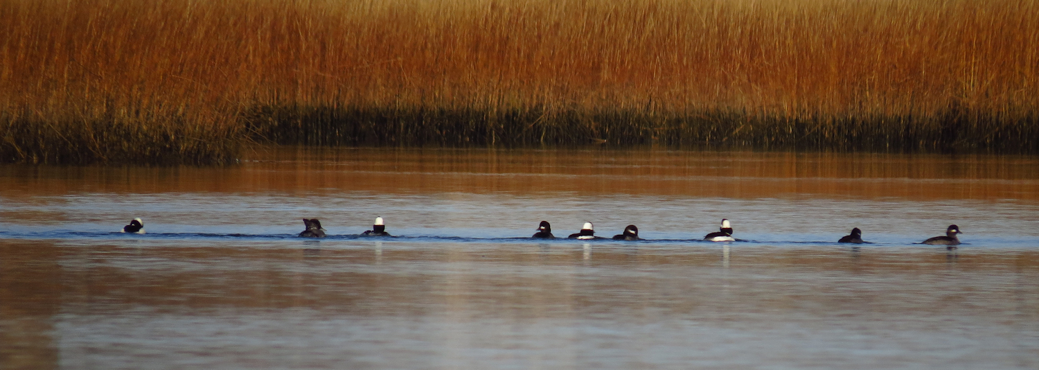
I spot three more Bald Eagles, several Great Blue Herons, and there are about 50 Mute Swans. The Swans winter in the cove and there will probably be a hundred or more later in the year.

There is some protection from the wind at the top of the cove due to the surrounding hills. I head up into the Moodus River. I find the lid of a ceramic creamer in the shallows. The short Moodus River once had thirteen yarn mills on it, and so it is not unusual to find old cast offs when the water is clear.  

The unmaintained dam

Cross the beaver dam or not cross the beaver dam. Yesterday's plan had been to go someplace where I would have to deal with dams, so cross it it is. This first dam is old and no longer maintained with no change in water depth. In most river levels, it is submerged. The second beaver dam is only a hundred yards up. This dam is maintained and has a 1 foot differential in water depth. There is a hidden lodge just upriver - the old winter browse stash in the water shows where it is. There is no point in crossing this dam as a log jam blocks the river just four canoe lengths up, and the paddling ends at the Johnsonville Dam about a 1/3 of a mile further on.

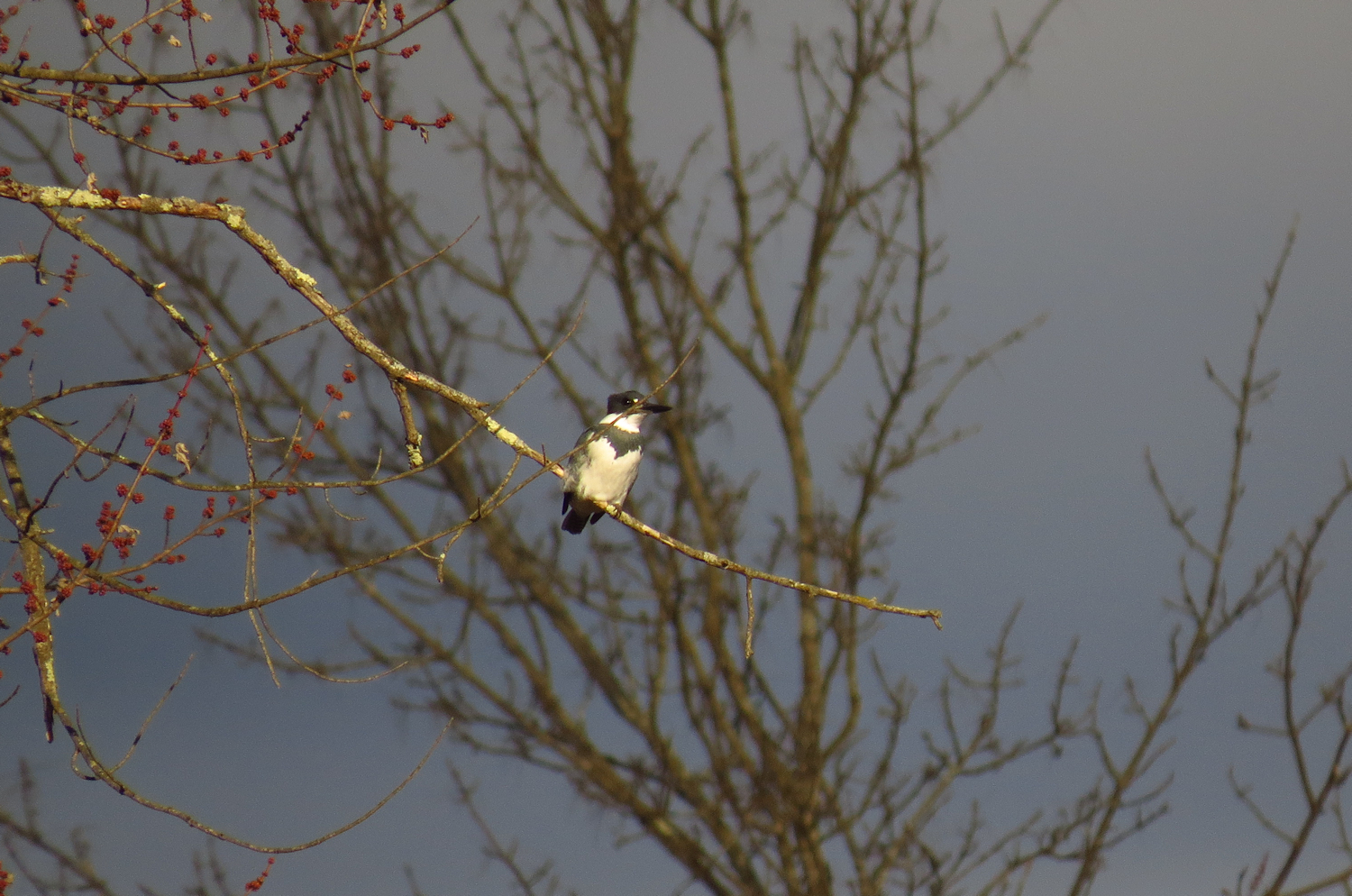
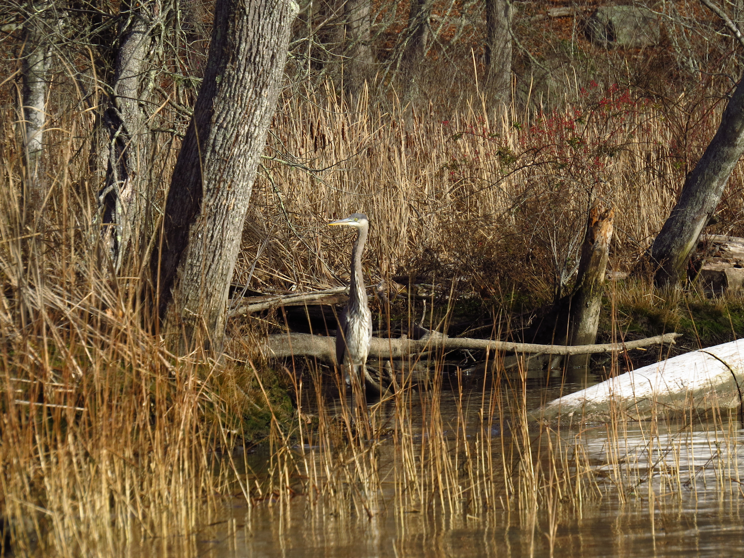
I head back to the Salmon River and with the wind lessening, I decide to go up and check out Pine Brook, where there is a large patch of wild rice. I test the rice, giving a couple stalks a shake. Grains fall straight away into the canoe. If I was interested in processing wild rice, it would be a good day to harvest it. I spot several Great Blue Herons and one medium sized that i cannot identify.

Wild Rice in Pine Brook

Getting back to the Salmon, I spot the Leesville bridge, and since the wind is even lighter now, I might as well go that far. I meet the canoeists with the kevlar canoe and have a good talk with them, giving them several tips for other day trips in the area.  Then, I head up to the Leesville Dam before turning back.

Wild Rice

I have some tailwind heading back, but the wind has clearly dropped off quite a bit. 

It was a good idea to go canoeing, who'd've thunk it.