Sunday, January 26, 2020

Predictions

I set out just before high tide, the water just a few inches below the boat launch parking lot.  It was a very short portage.
There was more wind than I expected, more than the weather service said.  But, it is almost a standard observation at this location.  Unless it is dead calm, there is always more wind than I expect.  But, there is a wind chill today, the air temperature about 35F and having grown up in winter country I know that the wind chill can cause you to overestimate the actual wind speed.

Buffleheads
I decide to head up Neck River and Bailey Creek.  The Sneak, which passes from Bailey Creek into the East River is one of the first canoeable passages to hold ice and I am curious to see if it is frozen.  I push a small flock of eight Buffleheads up the river.  Every time I near them they fly up a bend or two and settle back in.  I spot two dozen Canada Geese out in the center of Ox Meadow (the island defined by the East and Neck Rivers and Bailey Creek).  The last time that I flush the Buffleheads a single male Common Merganser is mixed in with them.

The Long Cut
The Sneak is open and well full with the high tide.  I turn off into the Long Cut before reaching the East River.  I'll have the wind and my face on the return and I seem to be sailing along at a good clip.  The Long Cut is also full and it is an easy paddle back into Bailey Creek, where I flush about 40 Black Ducks and about the same number of Canada Geese.  Then I continue up until I get to the canoeable end where it flows through a small submerged culvert.

Bailey Creek
It is a headwind paddle on the way out.  Although high tide was about an hour ago, the water is still rising.  The onshore wind is pushing the water level up a few inches over the predicted tide level.  The trip is a short one, just two hours and I finish about an hour and a half after high tide.  But, the water at the launch is higher than when I started by about 3 inches due to the wind.

Wednesday, January 15, 2020

The Bridges

The wind is stronger than the weather service predicted.  I expected a rather mild 7 mph breeze but here in the open land of the marsh it feels about double of that.  Anyway, it is not so strong as to be a problem and while it is in my face as I head out, the flood tide is at my back.

The Railroad Bridge
So, I grind up the river into the headwind.  I'll rest when I get to my turn around point as resting on the way in means losing ground.  I flush a couple Buffleheads in the firs bend and spot a mature Bald Eagle perched on Cedar Island.  Bird life is rather sparse today - a few Black Ducks at the first Big Bend and a small flock of Canada Geese at the second Big Bend, three Kingfishers along the way and a few Crows. 
The Post Road Bridge
The wind turns out to be less than enthusiastic.  Anytime I am near a stand of trees or bit of high ground the wind gives up.
The highway bridge

It is work up through the marsh but a feeling of being embraced comes to me as I pass through the Arch Bridge.  Here is where the forest starts, here is where the horizons move close and I am surrounded by the hardwood forest and the historical features that lie within.  Out of view to my left is the remains of the Parmalee Sawmill dam.  To my right, through the bare underbrush is the stone wall that contains the smallpox cemetery.  Ahead is the early 19th century farmhouse.  Soon, I will be at Foote Bridge, which once was the ford where the stagecoaches would cross the river. 
The Arch Bridge

It is an easy return.  The wind has dropped some, but it is also on my back.  The day has warmed as if the golden colors of the marsh are embers.  I pass a boat tied off to the Post Road Bridge.  The occupants don't notice me.  The diver they are supposed to be watching out for spies me first, surfacing between the bridge pilings where they must be doing an inspection.
Foote Bridge - the old stagecoach crossing

I take the Sneak over to Bailey Creek and finish via the Neck River.

Tuesday, January 7, 2020

Mattabesset River - First Trip of the Year

 
I put in at the old tavern launch. The tavern doesn't exist anymore, but the launch does.  This river would be one of Connecticut's best day trips if the traffic noise from a nearby main road wasn't so loud.  Even so, it is still a good area with lots of wildlife and a large marshland buffer that preserves a certain amount of wildness...it's just the noise that detracts.

The low winter sun is filtering through a the clouds causing a golden glow on the landscape.  The air is near calm and about 40F...pretty mild for this time of year.
Coming down out of the forest I spot a low beaver bank burrow.  It may be in use as it looks sealed well enough.  I would expect more winter feed than there is to be stashed in the water.  A few hundred yards further is a lodge that I remember from past trips.  It's another bank burrow, but it is collapsing and not in use.  Abandoned beaver lodges collapse quite fast disappearing from common view in two or three years although if you rummage around the stick debris lasts much longer.

The next lodge is just above the broadest area of the marsh.  Because of its high conical shape, I name it the Tepee beaver lodge.  The peak is a full 6 feet high and this colony, no doubt, is raising young.  Lodges get enlarged when the mated pair start reproducing.   I do a photo survey of the lodge, shooting pictures from the cardinal directions.
Tepee Beaver Lodge
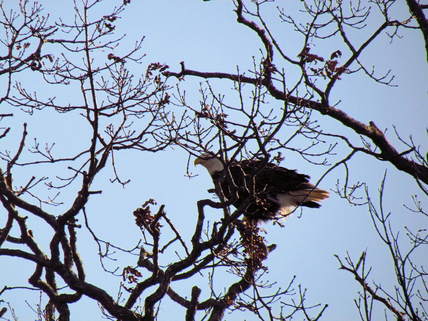
I spot a perched Bald Eagle about a 1/4 mile below.  When I get there I find four muskrat lodges in plain sight.  I wonder how many the Eagle can see from its perch.  The nearby eagle nest doesn't look used.  I didn't see any activity last year.
Muskrat lodge - about 30 inches tall with old eagle nest in the tree behind
As I make the few meanders to the mouth of the river where it meets the much larger Connecticut River, I spot another pair of lodges situated about 75 yards apart (pretty close for beaver that are very much territorial).  The nearest is a low and fairly new bank burrow.  Farther in along a dead end channel is a much larger bank burrow built using the root ball of a downed tree...Root Ball Lodge and Near Root Ball Lodge go the names.
Root Ball Lodge
I turn back from the mouth of the river.  As soon as I can see it, I spot the Eagle still perched although it leaves soon after.

After passing Tepee Lodge I almost paddle under a Red Tail Hawk before seeing it.  I do get a nice close up view of its coloring as it flushes.