Tuesday, February 27, 2024

The Home Turf

I put in from the wildlife refuge "ramp" such as it is. It is foggy and near 40F with the temperature rising, as is the tide which has another hour and a quarter to go before peak. I flush about 75 Canada Geese while getting started. A harrier flies by with a smaller bird harassing it. With the backlighting, I can't ID the litle bird until it pulls up into a hover - Kingfisher.


I set out across the bottom of the marsh. Once I'm 50 yards from shore, the east wind starts pushing me. It is stronger than the weather prediction, and feels like something just shy of 15 mph. As I paddle the 1/2 mile over to the bottom of Nell's Channel, flocks of Geese and Black Ducks take wing. Sometimes, I'm close enough to blame, and sometimes they are way too far off for me to be the cause. In the fog, the best navigation landmark is the big speed limit sign at the entrance to the channel. It has a particularly shaggy immature Bald Eagle perching on it.

The sun has burned through by the time I get to the channel.

I head up the channel, figuring out soon that I want to cross over to the east side of the channel and paddle in the six foot strip of smoother water next to the bank. There's nowhere for me to hide from the crosswind, but the foot high bank does make a difference on my 16 foot canoe. 

I head up into Beaver Creek, which for once is almost devoid of any birds. I come back and take the shortcut over to Cat Island. The last 50 yards are a stiff push as the minimal water path is choked with a winter's worth of dead reeds and grasses. Likewise for the route around the back of the Island, which requires a bit of wading today. I flush a Great Blue Heron while I'm back there.

Monday, February 26, 2024

Pre-Spring Mattabasset

It rains some and there is a bit of wind at home, but by the time I put in, it is sunny and the low 30F temperature is quickly climbing.

I put in at the usual spot. The water level in the big river is down at normal levels, about 4-1/2 feet on the Hartford gauge. The tide is coming in, but the high water mark from the last high tide is still about 15 inches up. This area is tidal freshwater marsh and swamp.

At the T-bend, a Common Merganser speeds through just two feet off the water. Then, I flush a Great Blue Heron that was standing unseen behind a large rootball. Nearby is a possible beaver bank burrow - a suspiciously well organized pile of branches without the mud packing that a lodge has.

Point Lodge
The large marshes on either side of the river look like they have been mowed. In a more normal winter, a good snowfall would have crushed the cattails and grasses, and that hasn't happened this year. It has been cold enough for thin sheet ice to form - probably not much more than a 1/4 inch here. I suspect that the ice formed, and with the tidal movement and some wind, much of the reeds and cattails have been trapped in the ice and sheared off. When one really looks at it, the height is quite uniform across the marsh.

I spot two immature Bald Eagles when I get down to the collapsed Tepee Lodges. I watch them for about 15 minutes. They are soaring and doing the Eagle mating dance - swooping at each other high in the air. I think these two adolescents aren't old enough to nest, but maybe next year. Then, I continue on down to the Coginchaug River. The Big Lodge, which is only a 1/4 mile in, just past the second bend, looks like it has been refurbished since the flooding that occurred a couple months ago. Two floods, six months apart were kind of tough on the local beaver. 


New Coginchaug Lodge
 About a 1/3 of a mile up from the Big Lodge is a brand new one. The new lodge is well built and has a large quantity of winter food stashed outside. Another 1/3 of a mile and I get to a downed tree crossing the river, which is not worth messing with since I know that I will get more of that soon enough. I turn and head back out the way I came.


Wednesday, February 21, 2024

Up to the Ice Edge

There are two bird watchers at my put-in when I get there. We chat and they tell me that they've seen four Bald Eagles and a pair of Golden Eagles. Four Bald Eagles is pretty much normal for this time of year and this place, but the Golden Eagles, that's a bit of a rare sighting.  There's a Loon out in mid stream and as I set out, there is a flock of Common Mergansers some distance up river.

The temperature is in the low 30's with a minor wind of no consequence. The sky is mostly cloudy, but opens up more as I paddle.

I follow the east shore up. My plan was to head into Hamburg Cove if the ice allowed, as it freezes first, being calm and protected with little current. The bird guys told me that it was open, at least where you can see it from the road. I love this first half mile up to the cove. The forested hillside looms over as I paddle along a shoreline that is either sand and gravel beach or sloping bedrock glazed with a thin layer of ice.

Golden Eagle
As I cross over to the far side of the cove's entrance, a large Eagle flies into sight. I decide it must be the big female from the Lord Cove nest - I've seen enough Eagles to know that this is a large one. But, I get a better view and better light as it turns, and it is not the big female. In fact, it is not a Bald Eagle at all, being all brown toned and much too large to  be and immature. It is one of the Golden Eagles.  My trip is paid for, so to speak.

I do find thin sheet ice in the cove in large patches but it is mostly open water. So, I just make a few minor detours to the plan and continue.

Ice fills the cove shore to shore starting about a half mile before the Joshuatown Bridge. So, I head back out.

I head a little upstream before remembering that I haven't paddled the shoreline below the put-in for several months. So, I turn and head down. Not far below the put-in is a property where the owner has been doing habitat restoration. Before he bought it, at least some of the land was owned by a collective of people for use as a private shoreline campsite (this riverside land is often unbuildable). I see these operations here and there in Connecticut. What may have sounded like a good idea usually ends up looking like a meth lab. The members haul in lawn furniture and barbecues, and leave it, too lazy to put it away after a weekend of partying. Wind and weather takes its toll and pretty soon there are small piles of broken lawn furniture, beach toys and barbecue parts laying in the surrounding forest. Anyway, ever since the new guy took over, the junk is gone and native plants are replacing invasives. This time, I especially notice that the forest in the upstream end of the property has been brushed out with problem plants cleared to promote proper forest development.

I get downriver about a 1/2 hour and then head back.

Tuesday, February 20, 2024

Menunketesuck

I put in on the Menunketesuck River. It is a fine day, although I start a bit late because the morning chill was less than inspiring. By the time I start, it is 30F with a 8-10 mph wind, which puts a nip on any exposed skin, mostly because I'm not used to it as we've had a very mild winter. The sky is clear.

The tide is about a 1/3 down and dropping. The Menunketesuck is canoeable at any tide level. The only restriction is the railroad bridge, which can have a strong enough current to make it impassable during the brunt of the tide change. The silt banks are well exposed. The consistency of this stuff - well, imagine a kid marching his GI Joe through a soft cow pie. It's a soft boot sucking goo, if one needs to get out of the canoe.

The recent snow has flattened much of the spartina on either side of the river. There are ice lines on some of the rocks showing last nights high tide. I spot a couple Kingfishers, and a couple Hooded Mergansers.

Just after the second bend, an Eagle overflies me. It is a second year Eagle with a spatter of white feathers on the head and tail. As I get near Opera Singer Point, the Eagle flies by again, this time with a friend. It's the last I see of them.

I turn and head up the east arm. In high water, one can cut the numerous meanders, but today I get the full tour. When I run out of water and spin the canoe, I alarm a small flock of Canada Geese, which stay put as I paddle away. 

Back in the main river, I head down to the RR bridge, flush 2 dozen Ducks - probably Blacks and Mallards. Another 2 dozen take off from way over in the west, too far off for me to be the cause. The current at the bridge is not too bad today, but there's not enough below to make it worth the bother.

On the way back up, I take in the west arm, as far as the hidden pond entrance, which is impassable without a carry. It has the look of an old dam that someone built just to have a pond. With that, I head back.


Monday, February 12, 2024

Eagle Check

It is a fine day with a temperature rising to somewhere in the mid 40's, and almost no wind. Tomorrow and the day following will be quite the opposite with a wet snow mix and wind gusts near 30mph.

I put in at Pilgrim Landing, the usual start for a trip into Lord Cove. My friend, D (we've spent enough time talking that "friend" seems appropriate) lives right next to the put in. He's messing with his garage door, so I go over and give him a hand. He is also the publisher of a fine full color magazine, "Estuary", which covers a range of topics that have to do with the lower Connecticut River. We get the garage door to a good enough status, and I head out.
For your reference, https://www.estuarymagazine.com/


It won't be long now until the Bald Eagles lay eggs. I try to get out and check on the nests that I know of at this time of year. All the way up in Lord Cove is a very productive nest that has fledged 3 Eaglets every year since I first found it. Fledging 1 is normal, 2 is great, 3 is awesome and it is a sign that the mated couple are exceptional hunters.
Buffleheads

The tide is still rising and it is an easy cruise with the current behind me. I find a few small groups of Buffleheads as I head up into the cove.  As I get up past Goose Bay where the channel narrows some, I start trading out the Buffleheads for Common Mergansers. Rounding the outside of Coults Hole I surprise a muskrat, which swims off into the Hole.

Muskrat 
If one comes here often enough, they might notice that there are several bedrock finger ridges that come off the hillside and protrude into the marsh. I don't know what geologic reason is behind the formations, but they break the east side of the marsh up into a series of small bays and miniature fjords. The big nest is in the last fjord. And, perched together in a tree on the inside of the turn into that last arm are two fairly large mature Bald Eagles. The nest is about 200 yards away, so this might be the nest pair. They let me pass under and I go look at the nest, which is in good order, although still not in use. On the way out, the two Eagles fly off, as a pair, in the direction of North Cove. They leave no doubt that they are paired.

Mission accomplished, I explore the other arms and bays, as I usually do when I'm in here. I flush some Canada Geese, maybe 2 dozen Black Ducks, and a pair of Teal. It's been easy and fast paddling with the tidal current and wind usually in my favor, so I take the long round about in Goose Bay. The western shore of the bay is a long spit that separates the cove from the main river. When I get there, I flush a large mature Bald Eagle. It has either a duck or muskrat in its talons. It does a short hop over to the far side of the spit. Then, I spot a second Eagle coming across the bay from the far side. It is a demonstration of the eyesight of Eagles, because that second Eagle was over half a mile away. It joins the first Eagle without any squabbling, so its safe to assume that they are a mated pair.

When I'm taking out, D comes over and hands me the new issue of Estuary and I fill him in on the Eagle sightings.

Friday, February 9, 2024

Day 1,252

The day starts cloudy, but it won't last. It will be in the mid 40's with a light south wind, pretty much anywhere I end up.

I return to the East River. For some time, it was my go-to river, and I have logged a good many days each year. I decided to expand my horizons some, so I haven't been here for about a year. I put in at the old wagon ford, almost at the top of the canoe navigable river. The tide, a very high one at that, will peak in a half hour. The tide current will be against me most of the time, both going out and coming back, but being on just either side of the high, the current won't be a bother, plus there is will be a light wind on my back when I return. It makes me sound almost smart.

Over the Gravel Flats
As I head down, I start remembering the place names that I've assigned - Pocket Knife Bend, where I dropped my knife into 3 feet of water. I continued on and on the return, when the tide had dropped, I stopped and retrieved it from a foot of water. Next come the Gravel Flats, although they are 5 feet deep right now. Then, I pass the Goffe house on river-left. She donated several hundred acres of forest land on the east side of the river to the town. The house looks like it's early 1800's. The forest is one of my favorite hiking spots. A quarter mile down on river-right, I pass a stone wall enclosure that can be seen if one knows where to look. It is the burial site of some Guilford militiamen who contracted smallpox during the French-Indian War (1760's). Just beyond on the other side of the river is the ruins of the Parmalee sawmill dam. It was an up-down sawmill sometime around 1860.

When I pass under the Clapboard Hill Bridge, I leave the cattail marsh behind. Although this next section isn't full on salt marsh, it must be just brackish enough that the cattails can't make it. Black periscopes out in the weeds show that there are a good number of Canada Geese. The migrators are on the left, the residents are pooping on the lawn of a house on the right. About half of the migrators flush and go off looking for someplace farther away from me. The residents just keep pooping. A dozen Black Ducks also take flight.

I have to duck to get under the Post Road bridge, I have to really duck to get under the railroad bridge. Now, I'm in the full on salt marsh, and it is well flooded. My favorite secret back channels are soawash that they are hard to make out, and they're not needed anyway. I cut across the marsh to Bailey Creek, then kinda sorta follow it down. 

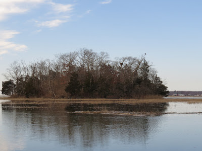
Cedar Island - Eagle to the right, nest in the fork left of the Eagle
There is an immature Bald Eagle perched on Cedar Island. When I scope it, I notice a new (new to me) nest. It might be an Eagle nest. It's in the trees, which is the wrong place for an Osprey, and Hawks don't spend much time here in the summer because the Willets harass them when they try to hunt.

I cut across the marsh to the state boat ramp, just to get a gauge on the water level. The parking lot is 6 to 8 inches deep. The clouds peel away to the east and expose the sun.

I return following the East River rather than the Neck River/Bailey Creek option. A flock of 20 Buffleheads passed over. Spot a medium sized Hawk just below the Post Road, but can't ID it.

Everything is the same all the way back to where I started, except that it comes in the reverse order.

Wednesday, February 7, 2024

Salmon Cove

The day is sunny without the forecast for wind that has been standard for the last few days. It's definitely worth a bit of extra driving to visit a favorite.

I put in at the bottom of Salmon Cove, where it joins the Connecticut River. No one else is in the expansive gravel lot. The water is higher than I'd expected, but still in the normal range. But, I now know that when the Hartford gauge hits 7 feet, there will be some water in the lot.

I head straight across the channel to a small opening in the cedar swamp that separates the cove from the main river. I 'm hoping to get in far enough to view the big beaver lodge from the backside, but the water goes shallow about a 1/4 mile in. I'll need some water in the parking lot to pull that idea off. But, while I'm in there I flush about 50 Canada Geese and maybe a 150 Mallards. The cedar swamp is a pretty good hang out for ducks that don't need a take off run - lots of little small patches of shallow water.I turn around and head back out.

There's a light north wind. It maybe hits 10mph, but it never holds that for long. It is of no concern. There are cirrus clouds and out on the horizon, some high stratus.

Then I head up the cove following the edge of the cedar swamp so I can check out the two big beaver lodges that lie within. The Big Lodge is well fortified for winter. The water level is just an inch below the top of the dam that they built to trap high water. The lodge is a full 6 feet tall. 

I head up further, flushing maybe two hundred Mallards and fifty Canada Geese. It has been a long time since I've seen that many water fowl in the air all at one time. They do not have far to go to find a place to settle as there is marsh all around.

The Duplex Lodge

The Duplex Lodge is in good condition with the divide between the two original structures starting to fill in. I wonder if the living spaces are both in use and connected. It stands 6 feet tall.

At the top of the cove I cross over to the Moodus. There are a couple patches of skim ice the size of a baseball field - 1/4 inch thick at most, but as it is rotting, it is full of bubbles and the canoe slices through it without slowing much. I paddle around it only because the ice chews on the edge of my traditional wood paddles. I find a new beaver cut tree just inside the river mouth - maybe 8-10 inch diameter. Some of the bark has been peeled, but the beaver aren't done with it yet. I'm not sure where the lodge is, but this is farther down than I normally find activity, so there might be a new lodge nearby. I head up to the fast water just below Johnsonville, and then come back out.

I turn up the Salmon River and go as far as Pine Brook, circling the two islands that lie off of that stream. The upper island has a really cool hybrid beaver lodge, something odd that I haven't seen before. There is a well built mud and wood conical lodge on the island, about 2-1/2 feet above the water, well up on the bank. I'm sure this started out as a bank burrow, which is a tunnel dug into the bank with an enlarged living space and with a pile of loose branches covering the vent hole. Our high water events must have flooded the bank burrow, but instead of abandoning the site, the beaver added a second floor by building a conical lodge over the burrow.

Eagle #1
On the way out, I spot a mature Bald Eagle at the bend in the cove. A second Eagle comes in from over my shoulder and they whistle at each other. They cross the channel, one at a time, continue whistling, keeping 50 or 75 yards between. It looks to me more like the beginning of a mating process rather than something territorial. It's just about that time of the year for Eagles.

Eagle #2

Friday, February 2, 2024

Lieutenant River

When I drove over the high bridge, it appeared that there might still be some skim ice on the big river. This hardly seemed likely, as we've had a few warm enough days with some rain. Of course, it is most likely just the gentle wind lightly rippling the water surface so that the seemingly endless overcast clouds shimmer in an icy reflection.

I put in on the Lieutenant River. It is one of those old friend rivers, big enough to be interesting, but never so upset by the weather to be threatening. No one else is around, of course. It is in the mid 40's with a light north wind and a scatter of rain drops that don't meet the definition of rain. The drops seem more to be water that got tired of drifting above on the air currents and it is never so much as to show on my clothing.

The bird of the day is the Common Merganser. I spot several small groups of male Mergansers. There may be some females, but at their scare distance, the males stand out clearly in their tuxedo feathering. A very noisy Hawk flies over. It might be a Sharp Shin based on the squared off tail.

The tide is out, but with a low tide coefficient for the day, the water never got down to its usual bottom. I cautiously paddle through Boulder Swamp, watching for the barely submerged canoe bangers that I know are there. With no wind on the water, they are doubly hidden. The Bald Eagles have not returned to their nest yet. The nest is easy to spot in winter, but when the leaves are out, it takes some staring up into the trees to find it, and it is only 20 yards from the water.

Mill Brook

I head up the bottom of Mill Brook. Usually this does not go at low tide. The water is quite clear. There are quite a few small pieces of broken pottery, as usual. Most of it is unidentifiable, too small to show off a distinctive curve that would tell me that it is a tea cup or plate or vase. The water is too low to paddle under the bridge, so I call it, far enough. There is about another 500 yards of brook up to an 18th century dam, but the frequent deadfalls often make it too much torture for such a short distance. On the way back out, I pick out a porcelain tea cup fragment. It has a printed design of a building with the words, "Education Building Albany, N..."

I head up into the top of Lieutenant River, flushing more Mergansers and working through the meanders until the marsh closes in. Then, I head back down.

I continue past my put-in wanting to check out the conditions on the big river. I spot a Harrier on the way. There is no ice on the river, so it was a figment of my imagination. But, there are a couple Loons out in mid channel and a group of four Long Tail Ducks, and another Male Merganser. With that, I call it a day and head back.