The day starts cloudy, but it won't last. It will be in the mid 40's with a light south wind, pretty much anywhere I end up.
I return to the East River. For some time, it was my go-to river, and I have logged a good many days each year. I decided to expand my horizons some, so I haven't been here for about a year. I put in at the old wagon ford, almost at the top of the canoe navigable river. The tide, a very high one at that, will peak in a half hour. The tide current will be against me most of the time, both going out and coming back, but being on just either side of the high, the current won't be a bother, plus there is will be a light wind on my back when I return. It makes me sound almost smart.
 |
| Over the Gravel Flats |
When I pass under the Clapboard Hill Bridge, I leave the cattail marsh behind. Although this next section isn't full on salt marsh, it must be just brackish enough that the cattails can't make it. Black periscopes out in the weeds show that there are a good number of Canada Geese. The migrators are on the left, the residents are pooping on the lawn of a house on the right. About half of the migrators flush and go off looking for someplace farther away from me. The residents just keep pooping. A dozen Black Ducks also take flight.
 |
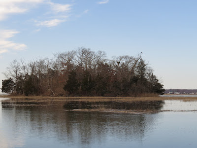
| Cedar Island - Eagle to the right, nest in the fork left of the Eagle |
I cut across the marsh to the state boat ramp, just to get a gauge on the water level. The parking lot is 6 to 8 inches deep. The clouds peel away to the east and expose the sun.
I return following the East River rather than the Neck River/Bailey Creek option. A flock of 20 Buffleheads passed over. Spot a medium sized Hawk just below the Post Road, but can't ID it.
Everything is the same all the way back to where I started, except that it comes in the reverse order.


No comments:
Post a Comment