Sunday, August 28, 2022

Doctor's Orders

 We put in on the North Cove in Essex. I don't think M has ever started here before, although we have started from Ely Ferry on the far side of the river.  It is a beautiful Sunday with moderate temperatures, a light wind, and an overcast that is soothing and keeping the sun off, at least for awhile.  We head out through the breach and straight across the river. There is little traffic in sight, so far.

As we reached the opposite shore, the number of bird sightings increased. It was mostly Great Egrets and Osprey with many Cormorants and a few Great Blue Herons.  All fish eaters, there is no doubt, there are a lot of menhaden and minnows in the river. M was impressed with the count. I mentioned that this is the fattening up season before migration. We headed down river.

I packed my tracking kit - plaster, a mixing bowl and some plastic strips to build a wall around an animal track. There is a good amount of exposed sand beach in this section, but the tide was just high enough to submerge most of it. When we spotted some tracks and went over to look, it was human and dog footprints - some boater giving their dog a break, not interesting enough to cast.

As we neared the entrance to Lord Cove, we lost the protection of Nott Island and began to get bounced by wakes from speeding boats on their way to twofer Bloody Mary's, or some such nonsense. It didn't last long and we turned into the backwaters of the cove.

On my last trip here, the Osprey were concentrated on the main river. There were big schools of menhaden in the main river on that day. Today, I'd guess that we're seeing the same number of birds, but they are wider dispersed - less on the main river, but more in the cove.

We paddle across Goose Bay and head up into the farther reaches of Lord Cove. The Osprey and Great Egret sightings are frequent. 

We pause for a minute or two at the small bridge...in the Bridge Inlet (my name), for three horse back riders to pass. The horses were definitely unsure about seeing a canoe below them. We do a quick check on the wild rice - no where near ready for harvest. Then we head out and up deeper into the cove to check on the Eagle nest. I didn't expect to see any Eagles on the nest, and they weren't. With that, we were 2-1/2 hours out and it was time to start moving in the return direction.

We pass a couple fishing for crab from a small outboard. M asks what they'll make with the catch...pasta dishes of some sort that i don't remember. Anyway, they are the first people that we've seen since leaving the main river. Today, it is very quiet back here. As we reach Goose Bay, M spots a large mature Bald Eagle. It might be the female from the nest we were looking at. I've seen her before, and she is very large (female Eagles are larger than the males). Back at Goose Bay, a flock of ten Mute Swans has moved in. M spots a large mature Bald Eagle

Back on the main river, we get bounced again by wakes. It's afternoon now and the sleepy heads of gotten out on the water with the big motors. While we were in the cove, I considered crossing the river and returning on the far shore, but this is area has fast boats and far too many of them, so we head back up behind Nott Island. We cross at the top of Nott Island, and although there is a lot of traffic, this is a slow speed zone and we make the crossing without any issues. 

M comments that she doesn't want to anthropomorphize the birds, but they look happy. A good observation, we talk about how active they are and that they may not be happy, but they are busy with lots of easy food to hunt and eat..and that would look to us like, "happy."

A fine day...just what the doctor ordered

Saturday, August 27, 2022

Geomorphology with Old Bottles

Five days ago, I retrieved a bottle from a steep bank in the salt marsh. After cleaning it, I was able to get a rough date on it - before 1920 and maybe the last half of the 19th century. Large air bubbles in the thick green glass put it before 1920. It had been closed with cork, the neck was bulged by design, the top was slightly deformed in the manufacturing, and the bottle had no embossed lettering or makers marks. Most likely, it was a beer or liquor bottle. Now, there was a second bottle sticking out of the bank at about the same level. With the low tide, I could not reach it, so I returned today timing my trip for a tide that was six or eight inches higher. I just had to find the same spot.


First bottle in center, second bottle above the bow of the canoe -Aug 22
 

The location was a inlet leading off of Nell's Channel. While I did not record the location, I did remember what it looked like. When I got down to the channel, I just checked each inlet on my left side. It was farther than I remembered, but the steep sides on the inlets left side made it obvious.  There was the bottle. I took compass bearings this time. 260 deg to the Bridgeport smoke stack, 015 degrees to the Milford smoke stack.

The bottle is 27-28 inches down from the top


Multi-sided, machine made, early screw top, clear glass

This bottle had a makers mark on the bottom - a simple capital F, and a mold number at the base - 486.
Dating the bottle was easy. It is a catsup bottle made by Owens between 1905-1916.

If you need to know more about bottle dating, try this site. It was originally hosted by the Bureau of Land Management. Suffice to say, it has enough detail for any archaeologist.
https://sha.org/bottle/dating.htm

There is no archaeological context for bottles found in the center of this marsh (or I would not touch it). No one ever built anything here - the bottles could have floated in on the tide from Long Island Sound, or they could've drifted in on the river, or someone might have just tossed them not too far from where I found them. What is interesting is that they were both about 27 inches below the surface and both bottles were made before 1920. Of course, I don't know when the bottles were actually tossed into the marsh, but it can't be much before 1920. Anyway, I can guess that it took maybe 75-100 years to build up 27 inches of earth in the marsh. Note that there isn't any standard for build up in a salt marsh, in fact, the build-up at this location probably varies from other spots in the same marsh...way too many variables in the process.

One thing I noticed when I first moved here (because I like digging through historic maps and comparing them to current land features) is that the spartina islands in the coastal salt marshes are pretty much the same sizes and shapes as they were in 1900. Another thing that I noticed was that the edges of the islands calve somewhat like glaciers. Not being a geologist, I imagine a situation where the marsh islands continue to gather "fill", either by silt being deposited, or by the deposition of a large annual mass of spartina and other marsh plants. The islands maintain shape by slowly compressing and forcing their edges outward, where they split off (there are often crevasses a few feet from the edge) and calve, with the calved chunks melting away in the river current.

The tide is flooding, and that means the marsh is filling - that curious thing where the current isn't moving upriver, but moving into the center of the marsh from all directions. I float up the "bottle" inlet and find it going very much farther than I expected. 

With the tide coming in, if I ground out, I only have to wait for a few minutes to continue. But, I wander around and eventually find my way to Milford Point. 

Juvenile Night Heron

There are lots of Snowy Egrets and juvenile Night Herons. A few Great Egrets, a few Great Blue Herons, and the Osprey are busy hunting. I circle the marsh and ride the flood current up river to my take out.


Wednesday, August 24, 2022

One Hundred Mallards in Fifteen Minutes

Green Heron
I head straight across the river and then up under the bridges aiming for the lowest entrance to the channels behind the four islands. Near that opening, a Great Egret and a Mallard, and an Osprey. A minute later, a Great Blue Heron, then two more Great Blue Herons and another Great Egret. Then, a dozen Ducks come in from over the shoreline trees. A few seconds go by and two dozen more come in. Then a steady scattered flock of fifty. They circle and then continue on to who knows where. I flush another thirty as I paddle up the narrow channel between Peacock and Carting Island. The Ducks are all Mallards - a hundred Mallards in the first fifteen minutes, not a bad start. Before getting to the top of the islands, I add a Green Heron and a Kingfisher.

Between Carting and Peacock Islands

I cross back over the river to get some shade and to paddle up the shallower channel on the east side of Fowler Island; there's never any boat traffic on that side. I flush a large mature Bald Eagle from the trees and watch it meander over Fowler Island to the far side of the river, not quite half a mile away. Even at that distance, I can follow the white spot of its tail on the background of dark trees. Then, a smaller bird, pops up. It's an Osprey and it makes a territorial dive at the Eagle. The Osprey disappears, the Eagle lands low, my view blocked by the island. A minute later, the Eagle flies up and perches in a tree. I make up a story that it forced the Osprey to abandon a fish. As I get above the island, the Eagle takes off and gathers altitude in wide circles over the river, and then flies off upriver.

I turn at the wind tunnel, crossing the river and picking up a gradually increasing current coming downriver as the the tide begins to drop. It's been a quiet day. I only saw two other boats and that was just 20 minutes from the end.


Monday, August 22, 2022

Break Time

I am an artist, and one of mediums is hand embroidered beadwork. My work is large, often photo realistic, and of course, detailed. I'm currently about ten months into a project that always seems to have another year left to completion. People, when they see my work, often ask me if it is hard on my eyes. I tell them it is not, rather it is hard on my butt, back and shoulders. I spend a lot of time sitting still sewing by hand. So, break time is all about moving.

Rain with possible thunderstorms was predicted for the day, but as is usual, the forecast is not particularly accurate. Although there is a light sprinkle as I head out, the weather report showed that any storm threats have headed either to the north or south of us.

I put in under the highway bridge and head down river to the marsh.  It is almost low tide, but it will be a higher than normal low tide. A good current speeds me along. 

Snowy Egrets - black bills, yellow rainboots
Low tide in the marsh limits route choices to the main channels - mostly an outer perimeter route. During very low tides, even this runs out of water in the south and east areas. However, low tide is especially good for wildlife observations as shore birds come out to pick over the exposed mud flats. None of the Egrets or Herons are perched in the east side trees - they're all down and feeding.

Maybe a migrating Stilt Sandpiper - smaller than a Yellow-Legs
As I near the marsh I start spotting Snowy Egrets. They like to eat small critters that hide in the shoreline sand or mud. Once I enter the marsh, it is clear that this is a good bird day. There are lots of Night Herons, and "lots" means two or three dozen for the day, several Great Blue Herons, some Great Egrets, the Yellow Legs are numerous, Semipalmated Plovers and a few sightings of what might be Stilt Sandpipers (longer billed and smaller than Yellow Legs).

Semipalmated Sandpiper

At Cat Island, I get by with about 8 inches of water, this is mud during a normal low tide. There are several large schools of minnows here - a Great Egret takes off and the water surface looks like someone just through a couple of handfuls of gravel as the schools kick up the surface. 

I can't make it through the lower east corner, only a few inches of water there, but the last cutoff has 8 or more inches of water and takes me all the way across to the top of Nell's Channel. I double the number of Night Heron and Snowy Egret sightings on this section.  I've seen far more Snowy Egrets today than I have in a long time. 

I retrieve an old bottle from the mud bank. It's a cork bottle and it was sticking out about two feet down from the top of the bank. It's green glass, no standard maker marks on the bottom, with rather thick glass, so it might be fairly old. You can't really date stuff based on depth in a slat marsh as there is no real rule to silt build up as opposed to, for example, tree rings. Anything in this marsh doesn't have an archaeological context - everything in here is something that floated in. There is a second bottle nearby, but I can't get at it without going knee deep in mud.

I exit the marsh out of Nell's Channel and have an easy paddle up the river. Break time is over.

Thursday, August 18, 2022

Selden

I started at Essex about a hour before low tide. It's sunny with a scattering of small clouds and a light wind coming down river. I head out from the North Cove through the breach, which is being watched by eight or ten Vultures.

I head upstream a short distance and then cross the river on the old Ely Ferry path. I find much more current than I expected, and crab at a 45 degree angle until I get into the shoreline eddies. What I was looking at when I decided to cross was the shade on this side. The shoreline here is a short steep forested hillside, much of it protected land. Osprey and Eagles are common sightings with excellent perches for them. But, I like paddling in the morning shade. As the sun warms the surrounding space, heavier cool air well steeped in the smells of forest plants, slips down the hill and out over the water, and the canoe. I'm being enveloped, wrapped in something from afar, even if "afar" is only fifty yards.

It is a slow paddle upriver, taking me an hour and quarter to get to Joshua Creek, and an hour and a half to get to the bottom of Seleden Channel. There is a usual amount of Osprey, Great Blue Herons, Great Egrets and Gulls. An immature Bald Eagle flies by. What is in unusual amounts though, is the recently hatched fish. Once I'm past the mouth of Hamburg Cove, there are thousands of minnow sized fish, and big schools of them, swirling and evading my nonexistent threat. It should be good fishing for Egrets and Herons.

I head up through the Selden Channel. It's the usual peaceful and scenic experience. But, it's still too shallow to check out the side channels. At the top of the channel I spot a feeding Green Heron doing an excellent job of snagging minnows.

Back in the river, I follow the edge of the island until I'm even with Eustasia Island, which is about 3/4 of the way across the river. I cross over and continue down.  There's a lot of motorboat traffic, but just as I think the rest of the trip will be...kind of a drag, the boats clear, and I have the river mostly to myself again.  The downriver run is not as fast as one might expect considering the tailwind. Unfortunately, today the tailwind is joined with some chop and waves.  Canoes tend to wallow some in a following sea, and it's busy paddling keeping the canoe on course. A mature Bald Eagle, and a large one at that, flies over.  

When I take  out, it has been a full four hour paddle.

Tuesday, August 16, 2022

Above Rocky Hill

I ended up at the ferry landing at Rocky Hill. The ferry is a three car barge with a tug lashed to the side. There has been a ferry here since 1655.

I've started here before, but I can't remember going upstream, so I go upstream. It doesn't take long to realize that I haven't been in this direction before. 

This section is flood plain river. Rivers cutting through wide flood plains often take on an isolated feeling even if they are close to the man-made.  If a flood plain is dry enough, it might be farmed. If not, it will remain a swamp or wet-footed forest. But, one would be a fool to build on it and it would be a waste of money to build anything more than a dirt road as the periodic floods (if not annual) would undo any "taming of the wild" efforts.The shoreline is forested, the banks are shallow silty sand, and behind the forest is farmland, as confirmed by a gas gun that goes off every few minutes to scare birds away from whatever is growing back there. Heading upstream, the river is 800 ft wide and makes a very long left hand bend. The bend is so gradual that I can see the put-in when I am a half hour out. The bend is so gradual that it takes an hour and a quarter of paddling before the river bends to the opposite direction.

There are no river front houses, no river front drives, and there is very little boat traffic. In fact, I will count only five boats above the ferry landing in almost three hours of paddling. I will count twice as many Great Blue Herons, plus one Kingfisher, one immature Bald Eagle, and one Osprey. It is a very nice trip.

Beaver Lodge

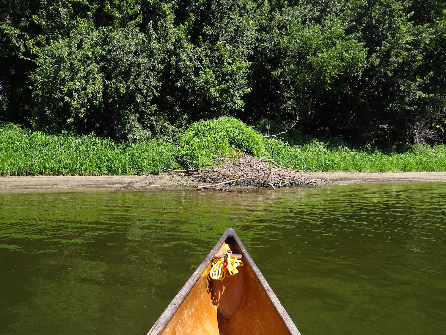
An out of place brush pile draws me to the bank. It is a beaver lodge although the actual lodge is hidden from view by brush. The brush pile is hiding the entrance, which is obvious enough if one is close, an excavated submerged channel leading out past the shallows. We have been short of rain lately, and the river is down about a foot or so below its normal level. The brush pile over the beaver lodge entry might be a recent addition to protect the opening. While the news is calling this a drought, it is better described as a dry spell - It really isn't that bad, and nothing compared to what the west is experiencing.

Notice the submerged entrance channel

An hour and a half out, just as the river starts to bend back to the right, I turn around. There is a small current, and it takes one hour to return to my put-in.

Monday, August 15, 2022

Submarine Day

I needed to change it up bit and I got as far as the Thames before getting bored with driving. Fortunately, the series of turns to get to the put-in are well signed. I start under two very tall highway bridges.

It's a good day with a light wind coming up the river. I haven't been here for two years or more. For another change, I cross the river directly and then head up river towards the sub base. I have to recross the river a few hundred yards before I get to the USS Nautilus, which is a floating museum piece, but a well guarded floating museum piece. The Nautilus is famous for reaching the North Pole under the ice pack 64 years and 12 days ago - 1958. 


As I start to check the river for boat traffic, so that I can make a easy crossing without dealing with the amateur mai-tai navy, I spot a big black void moving in my direction. I continue up the shoreline as the big void approaches, it is a submarine coming down the river and I prefer to pass well behind it. It is well guarded by a couple patrol boats, and the patrol boats and me have an unspoken mutual agreement to not speak to each other... they don't want to bother with me, and I don't want them to bother with me.  Once the sub has passed, I make the half mile crossing over to the west side.

One thing that I notice today as I paddle up past the base is that the patrol boats are not shadowing civilian boat traffic like they have in the past. It's just something that gets me wondering, and I imagine that they have other methods at play.

I follow the west shore up past the sub base. Much of this is a rocky and forested shoreline. However, the wind is building and I decide to turn around a mile or so before usual. The return is against the wind land the water has developed a good chop. But, I figure out why the patrol boats are less than enthusiastic. I notice a small civilian fishing boat motor past for the third time. If you sped by in a motorboat, you wouldn't notice, but at canoe speed, it's a little obvious. Three people are on board, one at the helm, one sitting on the foredeck, and one standing in the stern. The person on the foredeck is dressed something like Tom Sawyer with a wide brim floppy hat, and hasn't left that position for about an hour. Looking carefully, I notice that they are wearing an inflatable pfd under their clothing. The person in the stern has been standing there the whole time as well. That person also has a hidden pfd and what looks like a large shoulder bag partially hidden under their clothing...with a pistol grip sticking out of the rear.  And they turn around and head back, fishermen that never quite get to the fishing.

There are a couple sunken wood vessels