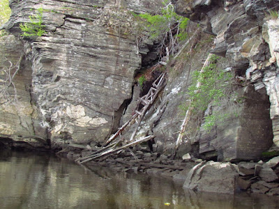
I put in below the small ferry dock...both the ferry and the dock being small. I head across the river and upstream mostly because it is no longer clear in my mind what was in that direction. I have only headed that way once or twice before. The first half mile is remembered though, the skirting under the cliffs that are under Gillette castle and the remnants of his trestles that ran along the cliff for his miniature steam train. Some of those ruins lie in the water while other portions remain fixed in place on the cliff.
I re-tune my eyes for observation, a couple weeks out of practice, looking for the out of place straight line and perfect circle, watching for the flash of movement in the forest. Osprey nests are spaced out with some regularity on the shore. A pileated woodpecker speeds through the forest never letting me get a clear look, but clinging to trees and being too large to be anything else.
Six kayakers are coming my way, still out several hundred yards and out in the main channel while I am behind the first island. I know without hearing them that they are talking, endlessly. At 300 yards, I can hear them, endlessly. I avoid contact and paddle past without acknowledgement. They are not where I am and I have no desire to be where they are. It is good enough that they are out.
 |
| entering Chapman Pond |
I pass a large patch of cobbles on a shallow shoreline that is silty sand by composition. This is not a natural feature and it is not unusual except that no structure stands nearby nor could any structure stand nearby, the bank being no more than a narrow natural dike between the river and a large marsh. It is likely a feature of the pre-steam industrial era, which also makes it pre-permit, pre-blueprint, pre-map. "Pre" things are not uncommon here. I find a number of pre-era dams and pretty much all of the endless miles of stone walls in the forests fall into the category (they also seem to be pre-compass as they are rarely aligned to any logical grid or compass heading). Out west I could refer to the earliest topo maps (1890-1900) and figure things out. It's not so easy here.
Ahead quite a ways was a bundle high in a tree that in silhouette looked to be a troll hunched over in the branches. I spot a bald eagle 100 yards downriver of the bundle, and the mate 200 yards above. It is their nest and it is four times larger than most any osprey nest that I've seen. I have passed enough landmarks that I now remember the details of this shoreline from my previous trips.
 |
| exiting Chapman Pond |
I know where I am.


No comments:
Post a Comment